Nanao push toward Buxiaowan
February 5-7, 2019
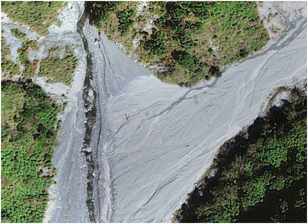
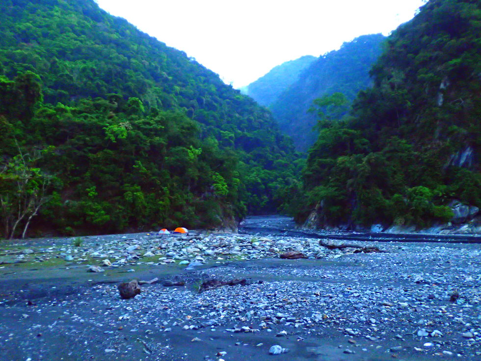
Confluence of Buxiaowan creek into Heping North stream where we camped in April 2018
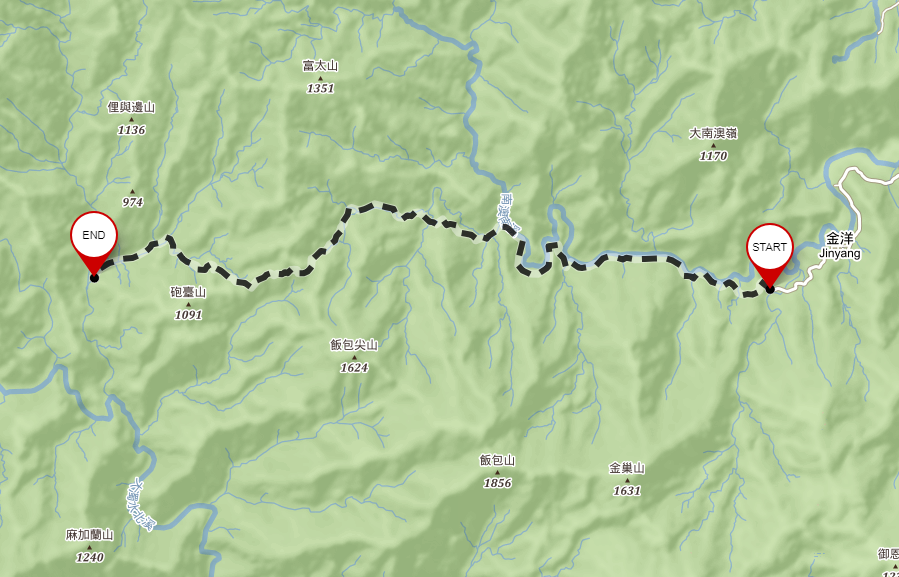
Hike in to check out the newly restored Nanao trail 南澳古道 and push through the end, try to follow the original trail and attempt to connect to the Buxiaowan stream 布蕭丸溪 drainage then trace downstream to the Heping Stream 和平溪, surveying possible hot spring sites along the way and exiting to the village of Heping on the Pacific coast.
Philip Diller | 0938-824-801 | philip.diller@gmail.com |
Leigh Hardy | 0930-144-643 | hardyleigh@yahoo.co.uk |
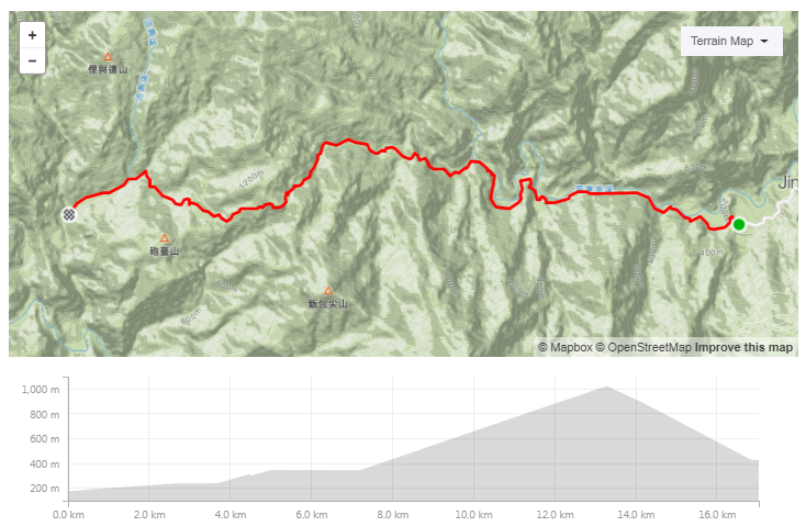
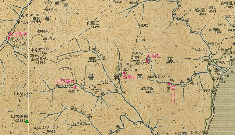
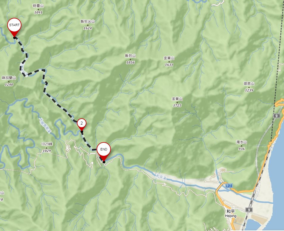
Leigh, Tammy and Philip will be picked up by Bruce and Wendy at Jiantan MRT at 6:35 AM. Drive to the Nanao trail 南澳古道 trailhead at the end of 宜57 in Ilan county, through the villages of 金洋村 and 仲岳岳 early on the first day of the Chinese New Year to avoid traffic. Hike in as far as possible on the Nanao trail. After a midday break, Philip and Leigh will continue along the trail. Our target for camp will be Buxiaowan 布蕭丸 (link to Central Geological Survey) hot springs (24.42182, 121.62267) at the confluence of Buxiaowan stream 布蕭丸溪 and Liuxing stream 流興溪.
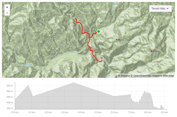
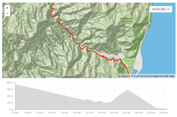
This is a 17 km walk with an elevation gain of 864 m.
https://www.strava.com/routes/16981417
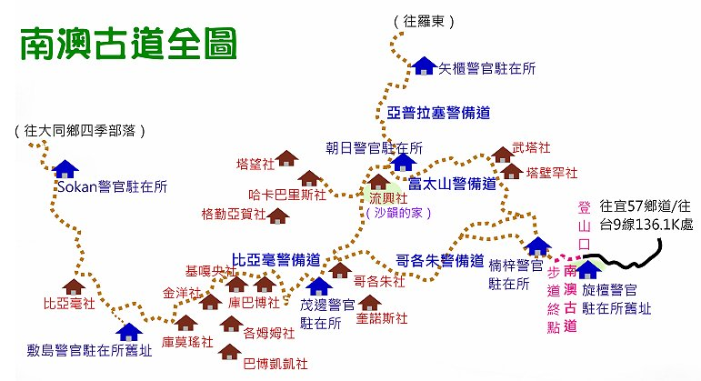
Nanao trail 南澳古道 is also known as 比亞毫古道 and 舊武塔古道. The trail connected numerous Atayal villages that previously flourished in the Nanao mountains, including 比亞毫 and 武塔 Butuseysya. The officially reopened part of the trail is only the first 3.8 k.
A WRA survey indicates two other hot springs further north up the Buxiaowan stream canyon which could be explored. Chougan 臭乾 and Maobian 茂邊 springs, they look close together in an area about twice the distance north up the Buxiaowan stream from the Dazhuoshui confluence.
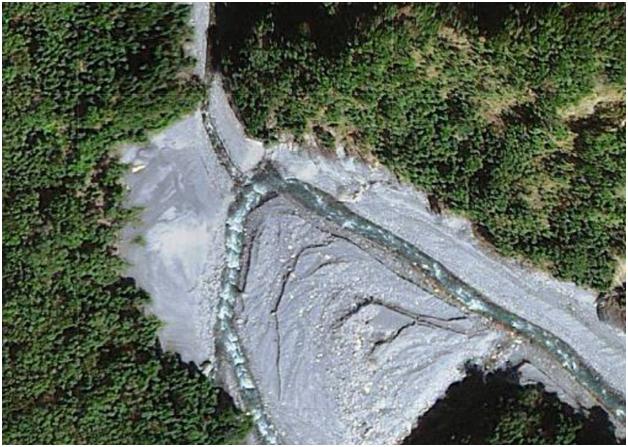
Image of first night’s target campsite where Liuxing stream 流興溪 flows into Buxiaowan stream 布蕭丸溪 and site of Buxiaowan hot springs 布蕭丸. There are supposed to be remains of the Atayal settlement of Liuxing nearby.
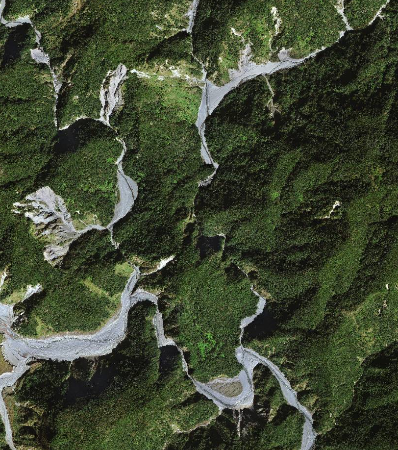
Image from NGIS https://ngis.wra.gov.tw/NgisGIS/
The biggest risk of day 1 is in the condition of the Nanao trail 南澳古道 to Buxiaowan stream 布蕭丸溪. If the trail is impassable, we will pitch camp and return to Nanao 南澳 the next day.
From Buxiaowan 布蕭丸 hot springs hike west and over a brief ridge into the Mohen stream then trace upstream to Mohen hot springs 莫很溫泉 (24.430872, 121.603544). In the afternoon trace down to the main Heping North stream 和平北溪 then to Dazhuoshui大濁水 (24.4048, 121.62383) hot springs at the confluence with Buxiaowan stream 布蕭丸溪 where we camped in April of 2918.
https://en.mapy.cz/s/3nio3 (incomplete)
https://www.strava.com/routes/16981652
Day 2 is a 9 km walk and river trace with an elevation gain of 491m. We did most of this trace in April 2018.
Imagery from Taiwan NGIS project https://ngis.wra.gov.tw/NgisGIS/
It seems that climbin over the peninsula to Mohen stream may be easier than negotiating the slot canyons approaching the confluence where Buxiaowan stream 布蕭丸溪 comes into Heping North stream 和平北溪.
Mohen 莫很溫泉 (24.430872, 121.603544)
莫很,位於宜蘭縣南澳鄉金洋村,定位點於(X): 310367 (Y): 2703059 海拔589m。 莫很溫泉位於和平北溪流域最上游,抵達較為困難,露頭沿溪零星散布。其主露頭湧水量大,泉溫接近90℃,屬噴泉型式,蒸騰的熱氣可達四、五層樓高。湧泉處沉澱有呈階梯狀的石灰華,然而水質分析結果中鈣離子的含量卻不高。一些在湧泉口有石灰華沉澱的溫泉都有此現象。可能是因其屬噴泉型式,湧出地表前後壓力差大,造成碳酸鈣快速沉澱(尚待進一步研究討論)。
Image of campsite where Buxiaowan stream 布蕭丸溪 comes into Heping North stream 和平北溪 (24.4047427, 121.6261929) also the site Dazhuoshui 大濁水 hot springs. We caped here in April 2018.
On Day 3 we will trace down Heping North Stream 和平北溪 to the Bihai Power Plant 碧海電廠 on the Heping main river 和平溪, then walk out to Heping village on the Heping forest road 和平林道 where we will catch a train back to Taipei.
https://www.strava.com/routes/16981839
Day 3 is a 12 km trace to the Bihai Power Plant 碧海電廠 dropping 240m, then a 12 km walk out to Heping village where we can catch a train back to Taipei.
和平林道,位於花蓮和平,大濁水溪的南側,全長我不清楚,但超過60K。目前在4.5K處 有林務局管理站,要乖乖申請入山證,10K處有一營運中的礦場,18K有兩道有鎖鐵柵欄, 為一般車輛行車終點,裡面實際可開到22K左右(2017/07),颱風後就不知道了。
林道上大約每7-8公里就有一水泥或是鐵皮工寮,19K兩棟水泥工寮、24K兩棟水泥工寮,附 近是杵望山登山口、33K長興工寮,以前是礦場、40K公寮,附近是曉星東峰的上切點,47K 公寮,是以前太魯閣七雄之一的曉星山登山口,最裡面、最神秘的溪北工作站,大概在6XK 左右。水源較不穩定,跟近期的雨量有關,23.5、24.5K有涓涓細流,27-28K之間也有山澗 ,不過海拔只有一千五百左右,對喝生水有疑慮的話還是煮過比較好。
前28K的林道很好走,28-30K中間有一處高繞跟一處低繞橫渡,小心慢行。當然林道越裡面 越難走。和平林道三寶:芒草、螞蝗、咬人貓,去的人要注意囉~ 前往和平林道的人很少 ,動物痕跡很多,我就目擊山羊兩隻,獼猴一隻,兩大四小的山豬家族在林道上,若干鳥 類。
Sunrise: 6:36
Sunset: 17:38
https://www.timeanddate.com/sun/taiwan/taipei
Nan'ao
https://www.cwb.gov.tw/V7e/observe/real/C0U77.htm
Hepinglindao
https://www.cwb.gov.tw/V7e/observe/real/C0Z22.htm
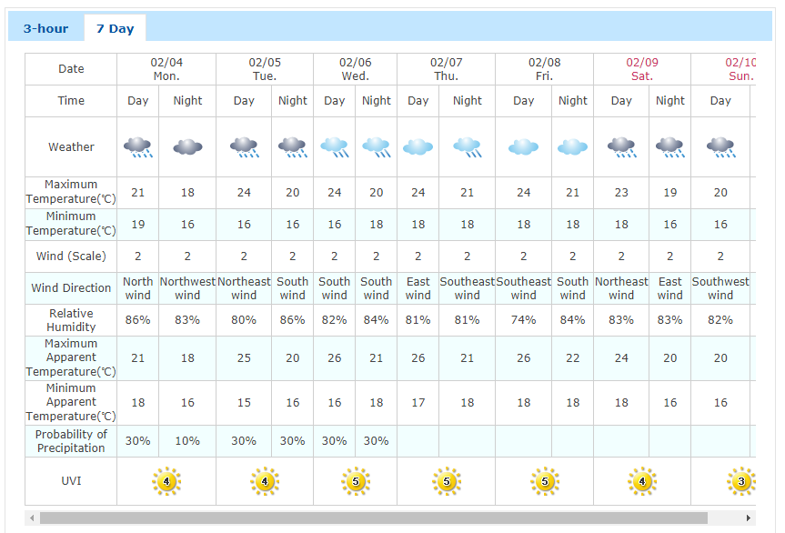
The Nanao weather station recorded 24.5 mm of rain on 2/3 and continuing rain accumulation on 2/4 of 6.5 mm. Though the Hepinglindao weather station located at the Bihai Power Plant 碧海電廠, did not record rain on 2/3, on 2/4 the station recorded 8.5 mm of accumulation.
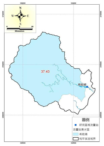
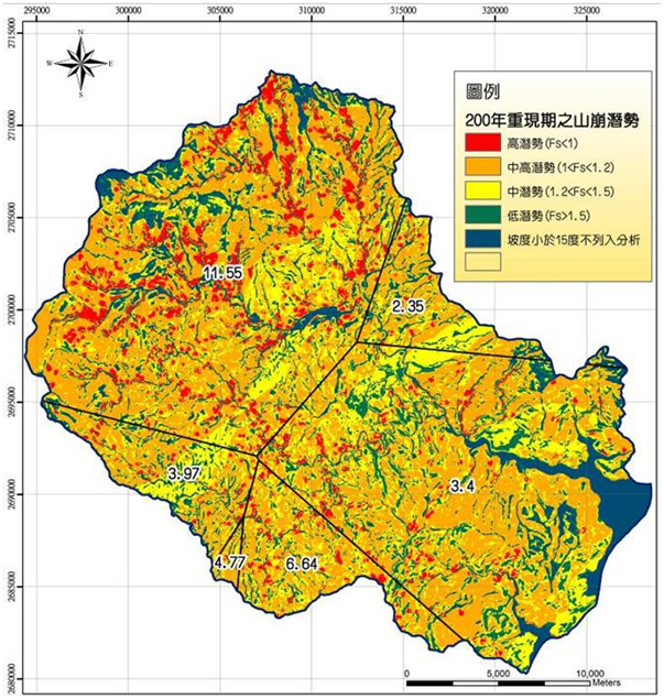
The Heping river 和平溪 watershed recharge rate is estimated at 37.43%.
The Heping cachement absorption rate based on US GIS S3 model based on 200 years of rainfall data and taking into account topology, groundwater levels, topsoil thickness, and soil hydraulics.
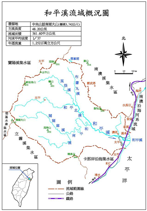
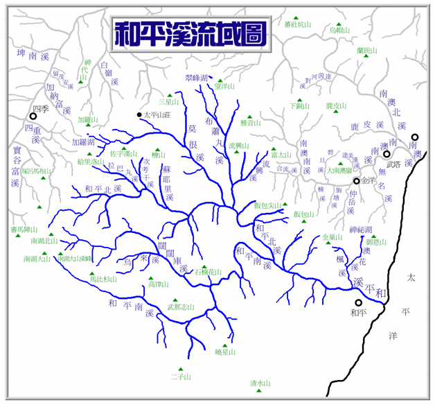
The Heping North river 和平北溪 and Heping South river 和平南溪 combined drain a 561 km2 watershed through the 48.2 km long river system originating from headwaters at Nanhuda mountain 南湖大山 in the central mountain range 中央山脈. The Heping river system 和平溪水系 is administered by the First River Management Office 第一河川局 of the Water Resources Agency 水利署 under the Ministry of Economic Affairs 經濟部. The bureau operates Xinengbu 希能埔 (xī néng bù) river water level measuring station, Station number 站號 2500H005 on the Heping River 和平溪 in Heping Village 和平村.
Date/Time | Xinengbu 希能埔 2500H003 River water height (meters) | Nan'ao 南澳 C0U77 Rainfall (millimeters) | Bihai 碧海 C0Z220 Rainfall (millimeters) | Nan'ao forecast | Hualian forecast |
2/4 11:50 | 29.4 m (dropping) | 6.5 mm (24h) 0 mm (last 1h) | 8.5 mm (24h) 0 mm (last 1h) | 0 % | 0 % |
2/4 13:40 | 29.3 m | 0 mm (last 1h) | 0 mm (last 1h) | 30 % | 0 % |
2/4 14:40 | 29.3 m | 0 mm (last 1h) | 0 mm (last 1h) | 0 % (2/5) | 10 % (2/5) |
2/4 20:50 | 29.4 m | 0 mm (last 1h) | 0 mm (last 1h) | 20 % (2/5) | 10 % (2/5) |
Data sources:
Water level at Xinengbu
Rainfall measurements
Weather Forecasts
Seven day trip starting from Nanao trail in April 2016. They reach Buxiaowan on day 2.
http://ys1128.blogspot.com/2016/04/201604010407.html
【宜蘭】莫很噴泉未竟。發現疑似基比亞罕古道支線(紀錄之一)
4 day hike out on Nanao trail, 2015/01 (photos)
https://hiking.biji.co/index.php?q=news&act=info&id=3510
Nanao trail out along the Nanao trail, April 2013
https://www.markchoo.com.tw/mark/2067
These guys seem to get to Buxiaowan in a full day in January 2016 (photos and map)
https://www.keepon.com.tw/thread-fac230c5-8ab3-e511-80c0-901b0e54a4e6.html
Four day loop from Nanao to Buxiaowan in March 2016. Detailed photos and maps linked from top of file. https://www.markchoo.com.tw/mark/2834
http://a180489.blogspot.com/2014/07/blog-post_4883.html
Tony Huang’s page on the Nanao Trail 南澳古道
http://www.tonyhuang39.com/tony0897/tony0897.html
An ethnobotanical memoir of A'tayals in Nanau (Chinese book)
https://e-info.org.tw/node/64077
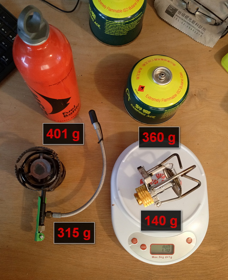
Leigh - stove, gas, camera
Philip - one fresh gas canister, cooking pot, first aid, permits
River - river shoes, helmet, wet suit, dry bag
General - Poncho, hat, headlight
Taking butane stove
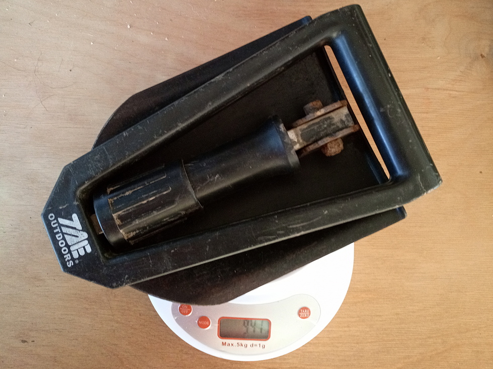
Will not take shovel.
Will not take machete.
宜蘭縣政府警察局受理臨櫃或現場辦理入山許可證處所一覽表
http://www.ilcpb.gov.tw/main/page_view.aspx?modid=1404
碧候派出所 | 金岳瀑布、澳花瀑布、南澳古道、四區溫泉、神秘湖 | 宜蘭縣南澳鄉碧候村信義路陽明巷78號 | 電話:03-9981903傳真:03-9981903 | 24小時 |
https://nv2.npa.gov.tw/NM103-604Client/
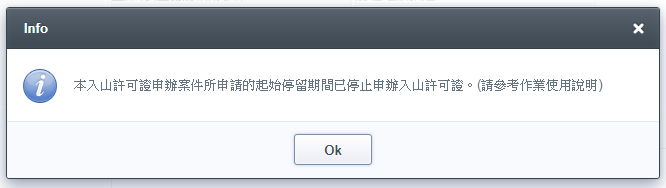
須於入山之日前5日至30日內提出
金洋村 -> 南澳古道 -> 布蕭丸 -> 和平溪 -> 和平林道 -> 和平