


photography by Dan
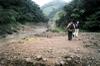
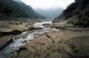
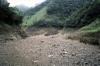
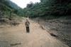
On March 24, 2002 Dan, Bruce and Philip walk in along the southern contour of the FeiTsui 翡翠 (emerald) reservoir along the access road from GuiShan 龜山. The weather is overcast and rainy all day. The water levels of the reservoir are noticeably low. The road is blocked by several landslides and washouts from last year's typhoon Nari, so the road quickly becomes overgrown. There are no hiking flags along the road but there are signs of some people having driven motorcycles in some distance, as well as signs of other hikers and trash from fishermen along the reservoir edge - especially exposed now that the levels are down - in front of signs announcing fines for littering and prohibiting fishing. We walked into several different valleys following the contours of reservoir fingers up into the valleys. We have probably walked less than a quarter of the distance to PingLin 坪林. There are several abandoned motorcycles and trucks along the road, facing in both directions. We walk down into a large drainage leading into the reservoir. The sedimentation levels are clearly exposed and the sand is very fine to walk on. soon after turning around here, it started raining and we get chilled on the long walk back despite a quick pace.