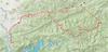
map

journal > keywords > map: 2022 | 2020 | 2019 | 2018 | 2017 | 2016 | 2015 | 2014 | 2003 | 2012 | 2011 | 2010 | 2009 | 2008 | 2007 | 2005 | 2002 | 1992 | 2009


2022

Nanshi-2022-08
5.61 km trace in 2 hours of upper Nanshi River 南勢溪

2020

26258521001_relive_1581823536250-2063
Bike loop with Bruce and Jack to Hans 手作 bakery
05488321001_relive_1581253748661-cut-1701
Ride on a cold wet day up Lane 120 off the road to Fushan
IMG_20200104_142827_7
soil and foundation profile
IMG_20200104_142702_9
site elements

2019

51328601001_relive_1575935738541_854x480
11.5 km trace up the Dajia River 大甲溪 from Guguan 谷關 to Maling Hot Spring 馬陵野溪溫泉
Hsinchu_to_Ilan-map
121 km ride from Hsinchu 內灣 to Ilan 羅東
IMG_20190817_133843_9
Nanao trail 南澳古道
07-21
6.25 km Wenshui stream 汶水溪 trace from Shuiyun Suspension Bridge 水雲吊橋 to Dashimen Falls 大石門瀑布 and Shuiyun Falls 水雲瀑布
41135760001_relive_1563854906628_854x480
6.25 km Wenshui stream 汶水溪 trace from Shuiyun Suspension Bridge 水雲吊橋 to Dashimen Falls 大石門瀑布 and Shuiyun Falls 水雲瀑布 (video)
toucheng
Toucheng Leisure Farm 頭城農場 visit
jiajiuliao
5.5 k Xindian river 新店溪 trace from Jiajiuliao 加九寮 to Guishan 龜山
4891421942_strava_1561856887647_854x480
5.5 k Xindian river 新店溪 trace from Jiajiuliao 加九寮 to Guishan 龜山
sanguang-baling
Trails down to the Sanguang River 三光溪
7626243542_strava_1560653376493_854x480
11.5 km river trace from Xuanyuan 萱源 to Tieshan waterfall 鐵柵瀑布 on the Sanguang River 三光溪
sanguang-trace-map
11.5 km river trace from Xuanyuan 萱源 to Tieshan waterfall 鐵柵瀑布 on the Sanguang River 三光溪
Yufeng-trace-map
12.2 km Yufeng River 玉峰溪 trace from Shalun Village 沙崙子 to Shuangfeng Waterfall 雙峰瀑布
9305803442_strava_1560301597886_854x480
12.2 km Yufeng River 玉峰溪 trace from Shalun Village 沙崙子 to Shuangfeng Waterfall 雙峰瀑布
Mohen_2019_Relive
A 50 km, 3 day hike along the Heping stream 和平溪 to reach the Mohen hot springs geysers 莫很噴泉
Nanao-d2-d3
Days 2 and 3 on the Nanao trail 南澳古道
d3map
Futai mountain 富太山 to Wuta 武塔
IMG_20190207_164743_0
Map of original Atayal villages
IMG_20190207_153825_6
Nanao trail 南澳古道
d2map
Tabihan village 塔壁罕社 to Mount Futai 富太山
d1map
Nanzi Police Station 楠梓警官駐在所 to Tabihan village 塔壁罕社
IMAG5198
The many former Atayal villages along the Nanao trail

2018

Fushan-Hapen
Walk from Fushan 福山 to Hapen 哈盆 in southern Taipei county
IMG_20181201_154812_0
Tongho trail 桶後越嶺古道
Fushan_walk
Fushan walk
xiaocukeng_map
Xiaocukeng trail 小粗坑古道
lanxi_trace
Lanxi stream 蘭溪 garbage survey
xiaomencun
Kuolai_Garmin_edge
115 km loop through Kualai 闊瀨
1209151071_strava_1531574118904_clipped
Kuolai
map from phone
image1
image2
image3
image4
image5
1289318951_strava_1527379064317_960x540
150 km North Cross island 北橫 ride
North_Cross_Island_Highway
150 km North Cross island 北橫 ride
8950329651_strava_1526219711214_960x540
10 km Wantan trail 灣潭古道 hike
wantan_Strava
10 km Wantan trail 灣潭古道 hike
IMAG2615
Heping-confluence-to-Buxiaowan-stream
20 km walk from Heping River 和平溪 to Buxiaowan stream 布蕭丸溪
8868804451_strava_1525217389795_960x540
heping_watershed
Heping watershed 和平流域
Bihai-to-Heping-confluence
4 km walk from Bihai Power Plant 碧海電廠 to Heping North Stream 和平北溪
Heping-to-Bihai
10.8 km drive from Heping 和平 village to Bihai Power Plant 碧海電廠
7088514251_strava_1524475341969_854x480
108 km ride up the Nanheng 南橫 with Bruce
South_Cross
108 km ride up the Nanheng 南橫 with Bruce
0788341251_strava_1524299257798_854x480
184 km ride with Bruce
HuaDong
Day 1 of Huadong 花東 184 km
3938980841_strava_1522480985998_854x480
7.12km Shenkeng 深坑 - Monkey Mountain ridge 猴山岳 - Caonan 草湳 hike with Dan
Shenkeng
7.12km Shenkeng 深坑 - Monkey Mountain ridge 猴山岳 - Caonan 草湳 hike with Dan
3683941741_strava_1521997934093_854x480
11k walk to Lelegu Hot Springs 樂樂谷溫泉
Lelegu
11k walk to Lelegu Hot Springs 樂樂谷溫泉
0293941741_strava_1521997959750_854x480
17.45k walk on the Batongguan trail 八通關古道
Batongguan
17.45k walk on the Batongguan trail 八通關古道
4865096541_strava_1521278647151_854x480
95k Sanxia 三峽 bike loop with Bruce
sanxia_strava_map
95k Sanxia 三峽 bike loop with Bruce
7479715341_strava_1520156699591_854x480
135k Five Finger mountain 五指山 loop with Guga
7479715341_strava_1520156699591
135k Five Finger mountain 五指山 loop with Guga
8780872241_strava_1519456117411_854x480
69k ride in Xindian 新店
tongho_map
69k ride in Xindian 新店
0192633141_strava_1518955942826_960x720
Sikanshui 四崁水 4.9 km hike
sikanshui
Sikanshui 四崁水 4.9 km hike
sijilindao_map
16 k walk from 1150 to 1750m on the Siji Forest Road 四季林道
5988506531_strava_1515922944476_854x480
62km, 1475m 新店 - 動物園 - 石碇 - 崩山 - 新店 loop
DSC_0748
IMAG1511
IMG_20180113_143502
IMAG1501
Lions_Head_map
37 km 630 m loop over Lion's head 獅仔頭山
IMG_20180110_115007-1
area tourist orientation

2017

Breakfast_meeting
84k Pingxi 坪溪 loop for breakfast meeting
lao_quan_jie
老泉街 explore
Daxueshan_map
110k ride on 大雪山林道
Pengshan_w_Ziggy_Guga
Taichung_136_battery_died
Taichung 台中 area bike ride
8122481711_strava_1504741530430_960x540
23k bike survey of Xindian river
river_survey
23k bike survey of Xindian river
20170907_065300
Taipower Guishan Hydroelectric Plant 台灣電力公司桂山發電廠
Fushan_8_12-13
Fushan overnight
4105351311_strava_1502638269911_640x480
Fushan overnight (map video)
54c8a54ef0707
simple hiking map
Fushan_0805_map
Nanshi stream 南勢溪 hike and trace
Relive_0805
(video)
beiheng
160km Northern Cross-Island Highway 北部橫貫公路
Fushan_yoyo
60.8km, 3 hour round trip to Fushan 福山 w/ Ziggy
tonghou-gweishan
烏來 - 孝義 - 龜山 - 四崁水 - 花園新城 44k ride w/ Ziggy
kuolai_drive_map
4.0 km drive from Kuolai 闊瀨 to 豹子廚
DSC_0432
trail map
walk_map
6.2 km walk over 263m in 3h55m
lulu_full
45 km Nantou hot springs explore
lulu_hike
5k hike down to hot springs
lulu_drive
5.6 km drive to trail head
erge
44.1 km ride in Mucha with Dan
satellite
out on the river and back along the road
tonghou
12.9 k trace and hike along the Tonghou stream 桶後溪
jingmeixindian
4.5 hour 12 km walk from Dan's to Philip's house
IMG_8297
DSC_8273
Zhang Xueliang memorial area
da-ai_site
area map
1483958867040
cadastral plots
tong_xi_light_background
key features

2016

dawu
25 km over 11 hours to Beidawu Mountain 北大武山
GOPR1929
Kuaigu hut 檜谷山莊
changxing
looking for route to ChangXing Road 長興路
maokong
10.6 km walk in Maokong 貓空
DSC_9717
DSC_9687
樟湖步道 Zhanghu Trail
lionshead
t11
Sheipa Park trails
IMG_2111
map check
IMG_7679
area map
Capture
10.3 km hike on Wantan trail 灣潭古道
DSC_9423
Taipingshan
107 km ride to Taipingshan 太平山
IMAG0128
DaTong 大同 map
118
113 km ride on Highway 118
kuolai
88k ride to Fulong
hike
5k hike
drive_and_walk
driving route
siji
20 km in 6 hrs on the 四季林道
Shiding
71.5 k Shiding 石碇 loop
baoqinggong_strava
40.9 km ride to BaoQing temple 保慶宮
Lions_head_hike
4.6 km walk, climbing 288 m
strava_map
17.6 k, 1482 m climb in 10 hours
ChaTianShan
map of trails of Chatianshan Reserve 插天山自然保留區

2015

hapen-hike
10.3k walk
track_map
61.1 km ride to Tonghou 桶后
map_track_Peter
river hike map
Fushan_hike
9.3k Fushan river hike
hike_map
Route of hike as tracked with GPS
bike_ride_map
map of bike ride
DSC_5754
Santa Fe River
DSC_4919
Concept design for the front of James' house and workshop area.
strave_map
Siqianshui 四嵌水 (sì qiàn shuǐ) hike

2014

bafu_camp_terrain
track of our hike
DSC_3785
a map we found on the trail
DSC_3783
a map we found on the trail
Fushan_streams
Fushan area streams
Fushan_rivers_mtns
streams and mountains around Fushan
tamshui
104.5 km ride to Tamshui 淡水
map
137.1 km Hsinchu 新竹 ride

2003

mingchi_landsat
Siling hot springs 四陵溫泉 area Landsat
mingchi_topo
Siling hot springs 四陵溫泉 area topo map
mingchi_road
Siling hot springs 四陵溫泉 area map

2012

strava
121 km Nanheng 南橫 bike ride
2012_Toucheng_ride
71.2 km ride to Toucheng 頭城

2011

anmashan
Dasyueshan National Forest Recreational Area 大雪山國家森林遊樂區
DSC_5179
Dasyueshan National Forest Recreational Area map

2010

DSC_8574
The Gate
m5_1
chiyou_map
Chihyou Mountain 池有山 trail map

2009

DSC_4081
area map

2008

hsuehshan
Wuling Farms 武陵農場 to Hsuehshan 雪山 hike map

2007

DSC_4830
DSC_4696
Penghu map
penghu_map
Penghu map

2005

sanguang_hike
Sanguang River 三光溪 map
ws_danshui
Danshui 淡水溪 watershed map
sanguang_sat
2m Landsat of Sanguang River 三光溪
sanguang_topo
25k topo map of Sanguang River 三光溪
Fushan_tm2
2m Landsat of Fushan area
Fushan_topo
Fushan area hiking map
DSCN5893
hiking trails off the highway
DSCN5882
DSCN5598
Guandu Nature Park

2002

fushan_2
Fushan-Hapen hike area
feitsui_area
FeiTsui Reservoir 翡翠水庫

1992

ynmap_5
Lijiang 麗江 map

2009

lapu_map
Lapu area hike map
Browse by: Years | Keywords | Locations | People