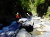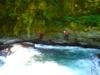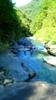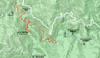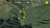
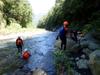
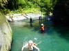
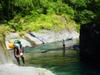
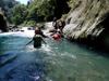
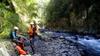
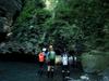
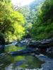
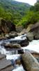
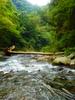
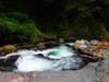
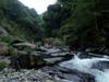
On a Sunday in early Fall, we drive to Baling 巴陵 on Road 7 台七 (the Northern Cross-island Highway 北部橫貫公路) to trace the Sanguang river 三光溪, turn up Galahe stream, trace up to the hot springs, trace back down to the Sanguang river and float down to the Dahan bridge where our group of six leaves one of our cars on the way in at our rendezvous at 9 AM. The remaining car shuttles the group up to Xuanyuan 萱源 at 52.4k where we park and climb down into the gorge to the Sanguang river.
哈嗄彎吊橋 Hagawan suspension bridge presumably formerly connected the community of Xuanyuan 萱源 on the east side of the SanGuang river 三光溪 gorge to the Atayal community of Ha-ga-wan 哈嗄彎 or 光華 Guanghua village in Chinese on the west side of the river gorge over Coiling Dragon Gorge 蟠龍谷. With an area of 126 square kilometers, Hualing Borough 華陵里 is over one third the area of Fuxing Township 復興區 and is the largest borough by area within Taoyuan county 桃園縣. The Northern Cross-island Highway 北部橫貫公路 (formerly 角板山三星警備道 Jiaobanshan Sanxing Police Garrison Road), bifurcates the borough into Guanghua 光華 (Ha-Ga-Wan in Tayal 哈嘎灣) on the south side and Baling 巴陵 on the north side. Ha-Ga-Wan settlement has a population of 1520, the residents are of Tayal 泰雅族 of the Gogan group settled in Wudao 武道能敢社 and Baling villages 巴陵社. 嘎拉賀 (Qrahu/Karaho/Qlaho) is a division of 哈嘎灣 Hakawan, renamed Guanghua 光華 after the war. The town Baling was populated by veterans who stayed there after construction of the road was completed. They brought in foreign farming practices of fruit and mushroom cultivation which led to land erosion and the early silt filling of the Shimen reservoir 石門水庫. Xuanyuan 萱原, Sileng 四稜 and Xicun 和西村 were not settlements but the sites of Japanese police stations.
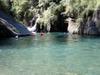
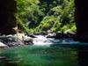
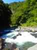
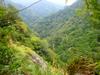
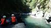
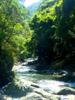
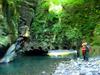
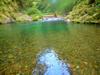
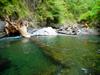
The canyon of the Sanguang River is in the Tatungshan formation 大桶山層 bordering on Miocene 中新世 Oligocene 漸新世 epochs in the Western Central Range terrane 中央山脈西翼 of the island.

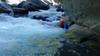
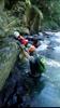
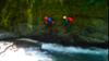

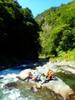
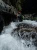
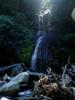
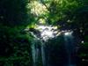
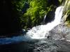
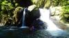
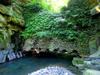
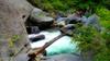
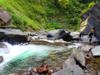
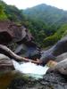
When we reach the confluence of Galahe creek we meet a group of canyoners coming down from Galahe who explain there is a waterfall on the creek and it will likely be impossible for us to make it up the creek with the equipment we have. We decide to trace up the stream some to take a look but then to trace upstream on the Sanguang and look for a way out before Tieza waterfall 鐵珊瀑布 to avoid the difficult slot between Galahe stream and Xuanyuan.
嘎拉賀 (gā lā hè) are Chinese characters used to represent the sound of the Tayal place name written with roman letters as Karaho, Qlaho, or Qrahu. The residents of Qrahu are Tayal 泰雅族 (often "Atayal"), the third-largest group of indigenous peoples on the island). "Qrahu" can mean "many", "great" or "chief" in the Tayal language. During the Japanese colonial era, the sound of the place name was represented by 唐穗 or カラホ ("karaho"). There is a Tayal legend that when a chief would go off to hunt, his companion would wait for him to return at Qrahu. The KMT renamed many places in Taoyuan to commemorate and glorify their national achievements after the war. The settlement was renamed 新興 (xīnxīng - "new prosperity") in 1947 which is what we see on modern maps.
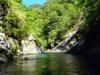
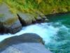
Galahe Stream 嘎拉賀溪 is a tributary of the Sanguang River. The Sanguang River 三光溪 drains a watershed of 107 square kilometers following highway 7北橫 and joining with Malikuomaru stream or 玉峰溪 Yufeng River at the village of Baling 巴陵 forming the the Dahan River 大漢溪 which eventually flows into the Xindian River 新店溪 then the Tamsui River 淡水河 flowing through the capital and into the Taiwan strait. The Tamsui River淡水河 the islands third longest river has a total length of 159 km and a drainage area of 2,726 km2.
Pyasan (Atayal) Fuxing District 復興區 is a mountain indigenous district in the southeast of incorporated Taoyuan City primarily populated by Atayal aborigines. The district is known for Lalashan 拉拉山 and Shimen Reservoir formed by Shimen Dam. Fuxing District borders to the north on the Wulai area 烏來 of Taipei county, to the east on Datong township 大同鄉 of Ilan county 宜蘭縣 and to the south on Jianshi township 尖石鄉 of Hsinchu County 新竹縣. With an area of 351 square kilometers Fuxing is the largest but least populated area of Taoyuan.
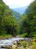
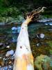
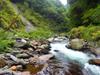
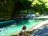
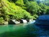
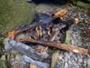
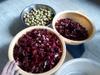
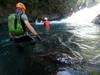
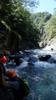
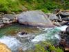
We see dead Taiwan Serow 長鬃山羊 (chǎng zōng shān yáng), 臺灣山羊 sidi (Bunun) Naemorhedus swinhoei, a protected endemic bovid and Reeves's Muntjac (Barking deer) 山羌 (shān qiāng) sakut (Bunun) Muntiacus reevesi in the river. We see three kinds of birds characteristic to lowland canyon rivers: the Brown dipper 河烏 (hé wū) Cinclus pallasii, the only all chocolate brown bird in the canyon, the Plumbeous water redstart 鉛色水鶇 (qiān sè shuǐ dōng) Phoenicurus fuliginosus, in the flycatcher family, and the Formosan whistling thrush 台灣紫嘯鶇 (tái wān zǐ xiào dōng) Myophonus insularis endemic to Taiwan. We meet several groups of fishermen. They are all having good luck catching 10 to 20 cm long Taiwan shovel-jaw carp 台灣鏟頜魚 (tái wān chǎn hé yú) more commonly called 苦花 (kǔ huā) Onychostoma barbatulum a species of ray-finned fish. Some are releasing their catch while some are taking them out or grilling them along the river.