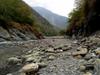

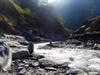
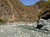
A few days before departing we checked the water level of the Danda river 丹大溪 in Nantou 南投 and saw that it was at a many year low. We changed plans from a hike up the Danda road 丹大林道 to a trace up the river to attempt to reach Jianianduan 加年端 hot spring which we had been unable to reach last year. The river level seemed to be 10-20 cm lower than it had been at the same time last year.
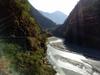
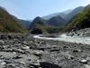
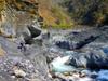
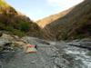
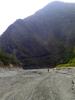
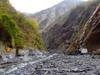
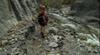
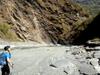
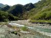
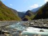
We drive down from Taipei on the eve of the holiday to avoid traffic and get an earlier start on our first day. We camp at 達瑪巒風味餐廳 again and drive back to D1li 地利 to have breakfast at Si Ka Ka where we are recognized. After breakfast, we drive to the end of Highway 16 台16線 at Heliuping 合流坪 where we will start our hike. There are so many cars parked at Heliuping that we have to drive back down the road to find a parking spot safe from rock fall. We don't see many people on the river though, so guess that most of the cars were for people hiking up the road.
The Danda river 丹大溪 is one of the 12 major tributaries of the Zhuoshui River 濁水溪, Taiwan’s longest river at 186 km. The headwaters of the Zhuoshui River 濁水溪 are at Hehuan mountain 合歡山 at an elevation of 3,220m. The watershed basin of the Zhuoshui River 濁水溪 has an area of 3,156.9 square kilometers. Annual average rainfall in the Zhuoshui River watershed 濁水溪流域 is 2,200 mm, which decreases moving from the mountains downstream toward the west coast. 70% to 85% of the rain falls during the rainy season from May to October, and the flow of the Zhuoshui river gradually decreases from October into the dry season in winter. The Danda river 丹大溪 quickly splits into the Danda river 丹大溪 and the Junda river 郡大溪 which each have significant tributaries all with headwaters over 3,000m.
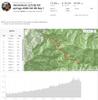
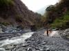
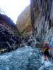
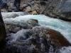
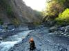
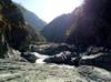
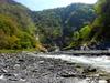
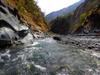
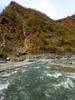
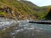
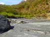
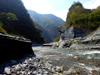
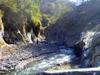
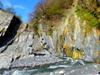
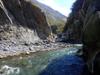
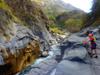
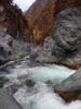
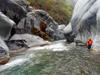
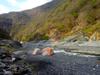
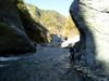
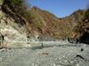
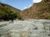
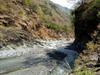
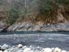
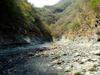
We take our first break for lunch at the Junda Stream 郡大溪 confluence. We have covered the nearly 8 km from Sun Hai Bridge 孫海喬 to the confluence in just over 2.5 hours, much faster than the nearly four hours we needed the year before. The speed difference may be partly due to our team being only two instead of five, but the greatest difference is that the river is a just a little lower and though the current is strong we will not use rope at all on the first day for stream crossings.
We named the first slot Sanfensuo 三分所 after the corresponding station on the Danda Road following the river far above the canyon. Willie's team will camp here with a view of the Sanfensuo 三分所 gate from there camp.
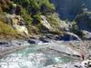
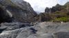
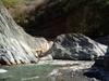
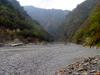
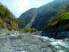
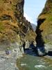
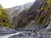
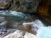
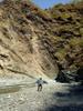
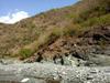
We quickly pass through the second slot area where we had camped last year and approach the slate cliffs. We are making fast progress and dreaming of how far upstream we might be able to camp.
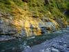
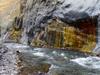
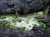
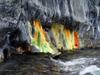
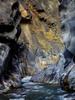
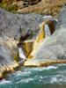
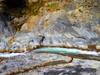
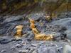
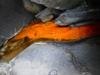
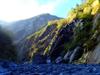
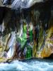
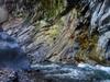
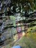
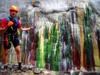
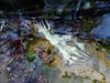
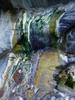
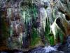
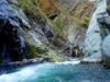
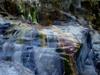
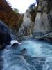
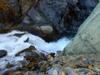
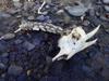
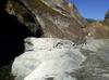
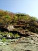
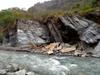
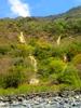
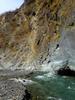
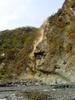
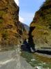
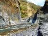
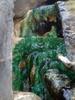
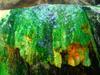
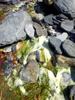
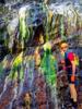
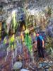
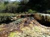
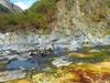
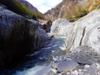
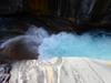
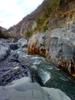
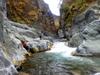
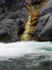
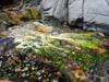
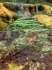
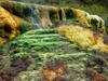
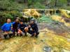
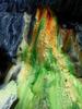
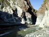
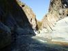
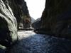
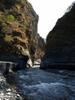
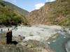
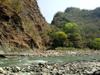
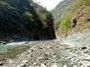
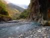
Aside from being in a wildlife preserve, the Danda river is a also an area of rich geological activity. Once we had traced over 10 km upstream from Heliuping 合流坪, the broad canyon narrows into slot canyons focusing the river. From here on there are hot spring outcrops about every hundred meters, spurting water sometimes too hot to stand and leaving colorful patterns of mineral accumulation. We did not hear wildlife from our tents over the thundering river nearby, but every square meter of sand along our walk was peppered with the tracks of deer. At first we thought this fantastic outcrop was our goal of Jianianduan, but we soon meet the group of 5 who had left Sunhai bridge before us with their dog. They are hiking down with full packs. They tell us that Jianianduan is another 20 minutes upstream and we share with them this outcrop which could too easily be overlooked.
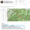
Campsite location: 23°44'36.1"N 121°04'22.8"E, 23.743363, 121.073010
Willie's team passes us going upstream at our camp. We had thought that travelling with his team would be safer and give us a better chance of getting through difficult sections of the canyon, but we are not ready to leave with him. We meet them again as we are both resting on our ways back down stream at Jianianduan.
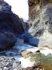
Slate cliffs (Where we got stuck in 2019): 23°44'21.9"N 121°04'45.7"E, 23.739420, 121.079354
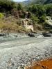
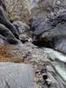
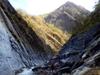
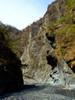
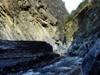
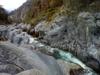
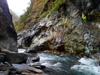
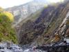
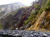
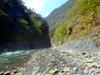
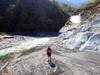
This section of nearly vertical broken slate cliff is where our team was unable to make further progress last year and turned around. With lower water levels and an early start on our second day and with only light back packs, we quickly pass and enter a section of the canyon new to us.
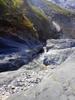
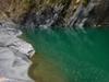
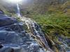
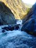
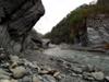
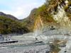
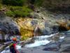
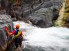
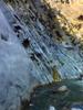
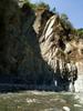
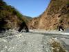
After smoothly passing the section which had blocked us last year, we quickly come to the next great obstacle a 7 m high waterfall. The water is powerful, but we find handholds to climb up through the powerful water fall climbing on broken rocks of the landslide dam underneath.
Waterfall: 23°44'24.3"N 121°04'56.6"E, 23.740076, 121.082399
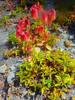
A survey conducted by the Forestry bureau using trap cameras along Danda road 丹大林道 at Sanfan station 三分所 and Lieufan station 六分所 station from Nov. 2012 to Oct. 2013 recorded 2870 photos of game in 41412 hours, including 5 herbivores - sambar deer, muntjac, serow, macaque, and boar; and 4 carnivores - marten, civet, weasel, and ferret badger. Occurrence was high for sambar deer and muntjac, but low for other game. The survey was used to put forward preservation policy for the area.
A 2004 survey along Danda road 丹大林道 conducted by Taiwan Normal University 台灣師範大學生物系 recorded 38 species of mammals, including 12 protected species:

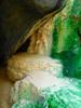
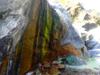
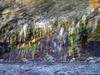
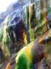
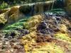
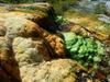
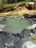
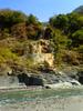
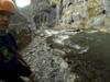
We arrive at Jianianduan 加年端 hot springs a short 40 minute, 2 km trace above our basecamp. The Jianianduan 加年端 outcrop is at 625m in the Danda river 丹大溪 in an exposed Miocene 中新世 Lushan formation 廬山層 of hard shale 硬頁岩 and brittle slate 板岩. The spring is named after the Bunun (布農) settlement of Qanituan (Bunun language) 加年端社 located above the canyon near the Danda Road 丹大林道. We meet a group who have camped at the spring. They walked down from the road the previous day and ask about the condition of the river to consider traveling out on a water route.
Jianianduan 加年端: 23°44'19.5"N 121°05'18.0"E, 23.738751, 121.088338
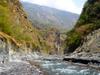
After a quick soak and warm up we continue upstream on the Danda river 丹大溪 with three others from a second group related to Willie's team toward Danda hot springs 丹大溪溫泉 which would probably be a good full day's trace further up the river canyon. The slot did not broaden back out as we had hoped but did continue to surprise us with stunning hot spring outcrops.
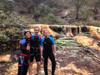

After a two hour trace another 4 km upstream we turn around an stop at Jianianduan again on our way back toward camp. Wilie's team comes through going back downstream reporting that they reached an impassable waterfall not far above where we turned around. Our return to camp completes a 12 km trace for the day.


With extra time on our third day returning to Sun Hai Bridge 孫海喬, we took a few hours to trace 2 km up the Junda 郡大溪 tributary flowing from the south. As we return we are overtaken by a group of three who report that they have been out for 10 days mapping abandoned Bunun villages and that they have seen signs of black bear. They show us photographs of some of the remarkably preserved buildings they have discovered.
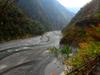
The lumber magnate Sun Hai 孫海 built a wooden bridge over the Zhuoshui River 濁水溪, Sun Hai Bridge 孫海喬 in 1957 to facilitate extraction of lumber from the central mountains along the then Sunhai Road 孫海林道. At the height of operations Sun Hai employed over 3,000 people and built the 80 km road from Shuili 水里 to Heliuping 合流坪 (known as Road 16 台16線 today) to connect with what is known today as Danda Forest Road 丹大林道. In 1969 Nantou County Government 南投縣政府 converted the bridge into a cement bridge and connecting to Danda Forest Road 丹大林道. This was the only route to Rainbow Lake 七彩湖. In July of 2004, typhoon Mindulle 敏督利颱風 washed away the bridge. The Executive Yuan decided not to rebuild Sun Hai Bridge. The Executive Yuan instead decided to build a suspension bridge only able to allow passage of motorcycles, to allow the Bunun people to travel to their home land, to allow travelers access to the high mountain environment and to allow Taiwan Power path to maintain the cross-island high voltage power lines. At that time the Forestry department also established the station at Sanfensuo 三分所 to control access to the area. In 2008, typhoon Sinlaku 辛樂克颱風 destroyed the suspension bridge and it was replaced with a cable gondola. When we visited in March, the gondola was out of service. Now the gondola seems repaired with new signs and locks strictly limiting its use to Forestry personnel.

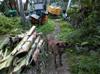
Returning to Sun Hai Bridge 孫海喬 and our vehicle we have traced over 18 km. As we pack up another group approaches us who recognizes us from our trip last year and also reports that they have come down from tracing up Junda Stream 郡大溪 where they documented Bunun ruins.