
Short trip to Nantou to drop off Brandon on the Danda Road 丹大林道.
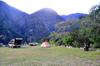
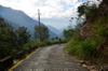
After driving down from Taipei, we camp one night at Damalan campsite 達瑪巒風味餐廳 near Tamazuan 地利 D1li in Xinyi district 信義鄉 of Nantou county 南投縣 a few kilometers before the end of Highway 16 台16線 at Heliuping 合流坪 where we will start our hike the next morning.
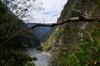
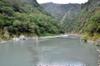
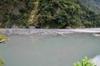
The lumber magnate, Sun Hai 孫海 built a wooden bridge over the Zhuoshui River 濁水溪 named Sun Hai Bridge 孫海橋 in 1957 to facilitate extraction of lumber from the Central Mountains along the then Sunhai Road 孫海林道. Sun Hai's company, Zhenchang Wood Company 振昌木業 was a awarded a logging concession from the Forestry Bureau of 5,000 hectares in the Dandalin area with the included conditions to build a bridge over the river and 68 km long logging road. At the height of operations Sun Hai employed over 3,000 people and built the 80 km road from Shuili 水里 to Heliuping 合流坪 (known as Road 16 台16線 today) to connect with what is known today as Danda Forest Road 丹大林道. In 1969 Nantou County Government 南投縣政府 converted the bridge into a cement bridge, connecting to Danda Forest Road 丹大林道 and providing the only route to Rainbow Lake 七彩湖 ("seven color lake"). In July of 2004, typhoon Mindulle 敏督利颱風 washed away the bridge. The Executive Yuan decided not to rebuild Sun Hai Bridge, but instead to build a suspension bridge only able allowing passage of motorcycles, to allow the Bunun people to travel to their homeland, to allow travelers access to the high mountain environment and to facilitate Taiwan Power to maintain the cross-island high voltage transmission lines. At that time the Forestry department also established the station at Sanfensuo 三分所 ("three tenths station") to control access to the area. In 2008, typhoon Sinlaku 辛樂克颱風 destroyed the suspension bridge and it was replaced with a cable car gondola which has since also failed. In the low water season, Taipower with the blessing of the Forestry Department place metal plates across the span of the Zhuoshui river to allow vehicles across. Ruined remains of these bridges are all visible at the crossing. In 2020, Nantou government announced plans to rebuild the bridge to the glee of many tourism related operators in the area, but raising debate among indigenous residents.


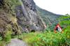
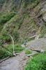
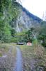
The road control point has moved down from Erfensuo 二分所 at about 5 km up the road down to the river confluence at Sunhai Bridge 孫海橋. As we slowly walk up the road we realize why. The road is riddled with landslides that would make it impossible for a four-wheeled vehicle to get very far.
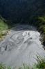
Both rivers are extremely silted. there is no sign of any passage for vehicles. We find a place to cross up on the Zhuoshui River 濁水溪 along old bridge pilings. Our footsteps sometimes pierce the lightly settled sediment floor of the stream causing our feet to sink another foot down into the river soft bed. We brought along a truck tire which we tested on the crossing the previous evening without Brandon's 70 pound pack.
The opening of the 68 km long Danda Forest Road 丹大林道 in 1958 replaced Guanmen trail 關門古道 which had been the essential path for the Bunun in the area. Danda Road was built to log the area now designated an important wildlife habitat. Today there is little sign of the magnificent original cypress forests檜木 which were replaced with regularly planted trees. The road is now maintained by Taiwan Power to allow maintenance of electrical power lines running up to Rainbow Lake 七彩湖 ("seven-color lake"), Taiwan’s second-deepest alpine lake at nearly 3,000 meters in elevation on the spine of the Central Mountain Range. Short numbered spur trails along the road leading to the electric power pylons, dot the length of the road. The distance from Sunhai Bridge孫海橋 on the west end, up to the lake is over 50 kilometers, so whether you walk up and back, or continue down Wanrong Forest Road 萬榮林道 on the east side to Fenglin 楓林 in Hualien花蓮, your walk will be over 100 km. Alternatively, Bunun porters can ferry you up on the back of the motorcycles they use for hunting on the hair-raising ride for a modest fortune. Climbing the west side, if you don't take shortcuts, you can visit Taiwan’s highest temple, Haitian Temple海天寺. From the lake at the top there is a three hour walk to Liushun Mtn 六順山, one of the two peaks under 3,000 meters of Taiwan's 100 peaks台灣百岳. Though most of the island's 81 Forest Roads were opened up in 2019, access to Danda Road still requires a Mountain Entry Permit入山許可證 from the National Police which is enforced by stationed officers of the Forestry Bureau at the beginning of the road.


Aul misnavatan (Bunun) The Danda river 丹大溪 is one of the 12 major tributaries of the Zhuoshui River 濁水溪 ("turbid river"), Taiwan's longest river at 186 km. The headwaters of the Zhuoshui River are at Hehuan mountain 合歡山 at an elevation of 3,220m. The watershed basin of the Zhuoshui River has an area of 3,157 square kilometers and is the island's second largest. Annual average rainfall in the Zhuoshui River watershed 濁水溪流域 is 2,200 mm, which decreases moving from the mountains downstream toward the west coast. 70% to 85% of the rain falls during the rainy season from May to October, and the flow of the Zhuoshui river gradually decreases from October into the dry season in winter. Correspondingly, there is a significant seasonal difference in the stream flow. Average monthly discharge is about 300 m3/s. Flows are high from June to September, and drop to only 30 m3/s during December and January, highlighting great disparity between the wet and dry seasons. The name of Zhuoshui means “turbid river" inspired by the large amounts of sand and mud born of the new geology, fragile rock, landslides, typhoons and heavy rains. Annual sediment transport from the Zhuoshui River basin reaches 63.87 megatons, accounting for 20% of the total 322.76 megatons washed down all of the island's rivers in a year. Above the confluence with the Zhuoshui River the Danda river quickly splits again into the Danda river 丹大溪 and the Junda river 郡大溪 which each have significant tributaries all with headwaters over 3,000m.
We find a wide grassy turnout in the road about 300 meters before a water source to camp for the night. After having pitched camp and eaten, a Bunun hunter comes down the road on his motorcycle with his gun. he explains that he has come down to get cell phone coverage to call his wife. He sits down in the grass right between us explaining that he has just trimmed this grass. He is on a crew contracted by the Forestry Bureau to clear brush to make fire breaks along the ridge above the road. He expresses annoyance that we have not hired porters for our trip, but we chat for a while and discover great common ground.
In July of 1989, the National Forest Bureau was restructured from a business organization into a public agency. Since then, the bureau no longer harvests trees for revenue. In the same year, it announced a ban on logging conifers 針葉一級木 (specifically the five trees: Taiwan Red Cypress or Formosan cypress 紅檜 (hóng kuaì) Chamaecyparis formosensis, Japanese cypress or Hinoki cypress 扁柏 (biǎn bo) Chamaecyparis obtusa, Taiwania 台灣杉 (tái wān shān) Taiwania cryptomerioides, Taiwan cunninghamia 香杉 (xiāng shān) Cunninghamia konishii, and Taiwan Incense-cedar 台灣肖楠 (tái wān xiào nán) Calocedrus formosana), bringing to an end large scale logging on Taiwan which had started in 1912, lasting over 70 years. Credit for this sea-change in national policy should be attributed to hiker, photographer and journalist Lai Chun-piao 賴春標's exposé of the rapacious lumber industry and ancillary illegal farming in the cleared land that he witnessed on trips to Cicai Lake and Danda Road in 1987. His reporting brought to public attention the logging industry in a series of revelatory essays in RenJian Magazine 人間雜誌. In the years following the ban, Taiwan's forest roads became access paths for tourists, hikers, hunters and mountain rats, memorializing decades of exploitation of the natural environment, mostly hidden from the public. In 2019, Taiwan’s 81 Forest Roads were officially opened to the public. Administrative control of some of these roads was transferred to local indigenous government.
Leaving Brandon in mid morning I collect three bags of trash on my way back to the car parked at the bridge. At the river a crowd of twenty odd weekenders cheers and films my crossing back across the Zhuoshui River. I remark to the Forestry guard that there is a lot of trash hoping that he'll offer to take the bags from me. He asks me where I collected the trash and I decide it's better to take the waste back myself.
The Forestry Bureau 林務局 manages 42,283 hectares in the Danda area, of which 14,350 hectares of forest have been cut down. In July of 1989, the Forest Bureau was restructured from a business organization into a public agency. Since then, the Bureau no longer harvests trees for revenue. In the same year, it announced a ban on logging confers 針葉一級木 (specifically Taiwan Red Cypress, Formosan cypress 紅檜 (hóng kuaì) Chamaecyparis formosensis, Japanese cypress, hinoki cypress 扁柏 (biǎn bo) Chamaecyparis obtusa, Taiwania 台灣杉 (tái wān shān) Taiwania cryptomerioides, Taiwan cunninghamia 香杉 (xiāng shān) Cunninghamia konishii and Taiwan Incense-cedar 台灣肖楠 (tái wān xiào nán) Calocedrus formosana) ending large scale logging which had started in 1912, lasting over 70 years. This change in national policy should credit the hiker and photojournalist's Lai Chun-piao 賴春標's exposé of the rapacious lumber industry and ancillary illegal farming in the cleared land that he witnessed on trips to Cicai Lake and Danda Road in 1987 and brought to public attention in a series of revelatory essays on the logging industry in the Danda area for RenJian Magazine 人間雜誌. The Habitat was established in February 2000 based on the Wildlife Conservation Act野生動物保育法. The habitat covers 10,547 ha ranging in altitude from 521 to 2,850 meters, spanning different climate zones to provide habitat for a broad representation of Taiwan's flora and wildlife.
Taiwan is a 36,000 square kilometer subtropical island. Steep mountains over 1,000 meters in elevation cover 32% of the island; hills and terraces between 100 meters and 1,000 meters make up 31%; while alluvial plains below 100 meters, where most human activity is concentrated, cover the remaining 37%. The northeast monsoon prevails from October through March. Typhoons and thunderstorms bring in abundant rainfall from May through September. The mountains are dominated by fractured, and deeply weathered metamorphic and sedimentary rock. Intense rainfall and flow of flood water causes severe erosion which is compounded by earthquakes which undermine the stability of the slopes. The rivers of the island's 16 major watersheds are short and steep, becoming torrential during heavy storms. About 78% of annual precipitation falls from May through October, with most water delivered by storms and typhoons. Taiwan enjoys the 13th highest precipitation rate of any country in the world, with an average annual rainfall of 2,515 millimeters or 90.5 billion cubic meters. Average annual runoff is 66.8 billion cubic meters, but rapid flows from steep slopes are difficult to store in rivers and highly irregular rainfall coupled with high population density, results in only 23% or about 15.4 billion cubic meters of water being available for use during the dry period from October through April or one-sixth of the world’s average value, which places Taiwan as the 18th highest water-deficient country in the world. With recent climate changes, the number of annual rainy days has decreased, but maximum daily rainfall and average annual daily rainfall intensity have increased indicating higher annual precipitation rates, but concentrated over fewer days in more intensive rainfall events.