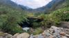

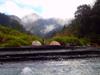
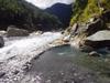
Weekend trip to explore Anping Forest Road 安平坑林道 in Nanao township 南澳鄉 of Yilan County 宜蘭縣. We drive from Taipei to the end of Anping Forest Road 安平坑林道 early Saturday, December 4 morning, climb down into the upper Nanao North River 南澳北溪 canyon near the end of the road, look for Yading Hot Springs 芽丁溫泉. Find a campsite and explore the river canyon and look for some of the other recorded hot spring outcrops before returning Sunday. The weather forecast suggests a 70% chance of light rain on Sunday.


Liba Industry Road 力霸產業道路 (an alternative name for Anpingkeng Forest Road 安平坑林道) is an 18 kilometer long forest road running through Dongshan 冬山, Nanao 南澳 and Datong 大同 townships of Yilan County 宜蘭縣 in northeast Taiwan continuing from Daan Road 大安路 in Anping Village 安平村 of Dongshan Township 冬山鄉. The length of the steep road is mostly paved except for sections passing through the quarries. At 5.8K there is a cable car relay station for transporting cement, and at 12.9K the entrance to the mining area. At its crest the road presents panoramic vistas overlooking the entire Lanyang Plain 蘭陽平原 and Guishan Island 龜山島 in the Pacific Ocean from an elevation of 1200 meters. The road provides access to Lankan Mountain 蘭崁山 and Dabai Mountain 大白山 trail heads, the two final peaks over 1000 meters in altitude before the central mountain range, stretching from Eluanbi at the southern tip of the island, tracing the spine of the island, dips back into the Pacific at Suao 蘇澳. The road became privately controlled when the Forestry Bureau 林務局 leased the road to the China Rebar Group 力霸水泥 in 1991 as an industrial road to mine limestone 石灰 found in the area. The cement works were renamed after the Rebar Group collapsed and Ruentex Materials 潤泰水泥 assumed the lease. For environmental and other reasons, the quarries along the road were gradually closed down. With the opening up of Taiwan’s 81 Forest Roads to the public in 2019, access to the road servicing the cement quarries was opened to the public on weekends and holidays only. The road crosses the Lanyang River 蘭陽河 and Heping West River 和平溪 catchments.
Taiwan is a 36,000 square kilometer subtropical island. Steep mountains over 1,000 meters in elevation cover 32% of the island; hills and terraces between 100 meters and 1,000 meters make up 31%; while alluvial plains below 100 meters, where most human activity is concentrated, cover the remaining 37%. The northeast monsoon prevails from October through March. Typhoons and thunderstorms bring in abundant rainfall from May through September. The mountains are dominated by fractured, and deeply weathered metamorphic and sedimentary rock. Intense rainfall and flow of flood water causes severe erosion which is compounded by earthquakes which undermine the stability of the slopes. The rivers of the island's 16 major watersheds are short and steep, becoming torrential during heavy storms. About 78% of annual precipitation falls from May through October, with most water delivered by storms and typhoons. Average annual rainfall is 2,515 millimeters or 90.5 billion cubic meters. Average annual runoff is 66.8 billion cubic meters, of which only 23% or about 15.4 billion cubic meters are available for use during the dry period from October through April. Annual pumped groundwater is estimated at 7.1 billion cubic meters. The Nanao River 南澳北溪 drains a catchment area of 311.73 square kilometers over its 48.40 kilometers length dropping over and average slope of 1:43. Over the past 42 years, average annual rainfall over the Nanao River watershed has been 2691 mm, with the maximum being 4794 mm in 1998 and the minimum being 1168 mm in 1993.


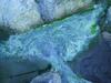


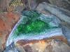


As hot water flows from the outcrop it may fill small pools where it will overflow forming a slowly accumulating wall of calcium carbonate precipitate at the edge, undisturbed this will grow steps of overflow deposits called travertine terraces 石灰華階地. These terraces host algae populations which provide vivid coloration which varies with the varying temperature of successive terraces. These are colloquially called 蛋糕狀石灰華池 in Chinese "Travertine cake pools."
It started raining a few hours before dawn and our tents are soaked. The sun comes in and out of cloud cover enough to dry off our stuff, but we keep and eye on the sky as the weather changes.


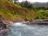


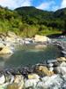
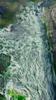
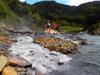
Yading hot springs 芽丁溫泉 outcrop emerging from fissures in the schist 片岩 at an altitude of 431 meters on the right bank, is the furthest upstream outcrop known on Nanao North Stream 南澳北溪. Calcium carbonate precipitation 碳酸鈣沉澱 around the spring and the high content of calcium ions 鈣離子 in the spring water may indicate the distribution of marble 大理岩 in the area. Exposed lithology at the outcrop is late paleozoic 古生代晚期, Dongao schist 東澳片岩, graphite schist 石墨片岩 and quartz mica schist 石英雲母片岩. The outcrop stretches over an area of about 20 meters. Measured water temperature is 55 C, with a pH of 6.5, EC (electrical conductivity) of 1148 µ/cm, and TDS (total dissolved solids) of 561 mg/L. Primary measured mineral constituents are Na, Ca, MG, HCO3 and SO4, MG and C. The first upstream outcrop emerges from a fragile sedimentary structure and waterfall stretching a dozen meters above the river level. A cluster of outcrops 50 meters downstream seems to emerge from the river bed and is much hotter. The 20 km drive along the dangerous industrial road of the Yilan limestone mines, steep and long descent down a loose boulder field into Nanao North stream canyon and difficult crossing of the swift river to reach the hot springs outcrops have all contributed to keeping this wild hot spring off the list of popular destinations. Continuing downstream from Yading, in roughly 2-3 km intervals the intrepid tracer will come across 烏帽溫泉 sometimes confused with Yading, 拉卡溫泉 or 五區溫泉 and finally 四區溫泉.


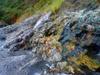
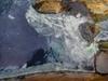
The most common origin of white seams in rock faces is fractures filled with quartz (SiO2) or calcite (CaCO3) resulting in clean straight white lines appearing to run across the surfaces of an outcrop or around a pebble. After rocks crack under pressure, the cracks may fill with fluid where crystals may precipitate forming relatively pure and clean (free of clay particles or organic matter) crystals so appearing colorless or white.


Taiwan is born of the ongoing complex collision of four different tectonic plates. This interaction results in distinct geological terranes. The Yilan area 宜蘭地 was formed in the Cenozoic 新生代 with fragile geology, much of the surface material is crushed marble and limestone, essential ingredients of cement. Yading hot springs lies in the Cenezoic Nanao formation just south of the Wansuishan fault 萬歲山斷層.