Junda Stream 郡大溪 Aul misnabukun

journal > 2021 > Junda Stream 郡大溪 Aul misnabukun


Damalan campsite 達瑪巒風味餐廳

Junda Stream 郡大溪 Aul misnabukun 20210402_004405
James pitching camp
Junda Stream 郡大溪 Aul misnabukun 20210402_004818
chicks incubated

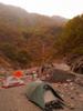
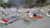
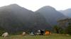
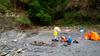
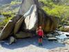
Damalan campsite 達瑪巒風味餐廳 has become our regular camp site over the years to drive down to, camp conveniently and get an early start on various adventures in the Danda area.

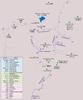
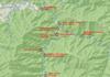
Competing with weekend holiday traffic, we arrive after midnight at Damalan campsite 達瑪巒風味餐廳 near Tamazuan 地利 D1li in Xinyi district 信義鄉 of Nantou county 南投縣 a few kilometers before the end of Highway 16 台16線 at Heliuping 合流坪 where we will start our hike the next morning.

Day 1: Sunhai Bridge 孫海喬 to slot canyon camp site

Damalan campsite 達瑪巒風味餐廳

Junda Stream 郡大溪 Aul misnabukun 20210402_061650
達瑪巒風味餐廳 Damalan campsite
Junda Stream 郡大溪 Aul misnabukun 20210402_061830
達瑪巒風味餐廳 Damalan campsite

Sun Hai Bridge 孫海喬 at Heliuping 合流坪

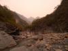
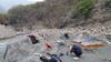
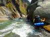
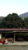
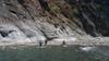
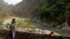
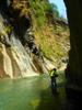
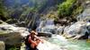
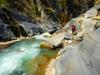
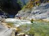
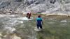
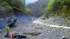
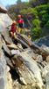
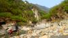
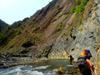
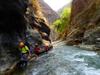
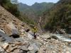
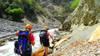
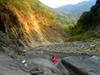
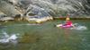
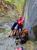
After breakfast we drive to the end of the 16 at at Heliuping 合流坪 to park and gear up for river tracing.

Junda Stream 郡大溪 Aul misnabukun 20210402_082908
parked at Heliuping 合流坪

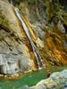
The lumber magnate Sun Hai 孫海 built a wooden bridge over the Zhuoshui River 濁水溪, Sun Hai Bridge 孫海喬 in 1957 to facilitate extraction of lumber from the central mountains along the then Sunhai Road 孫海林道. At the height of operations Sun Hai employed over 3,000 people and built the 80 km road from Shuili 水里 to Heliuping 合流坪 (known as Road 16 台16線 today) to connect with what is known today as Danda Forest Road 丹大林道. In 1969 Nantou County Government 南投縣政府 converted the bridge into a cement bridge. Connecting to Danda Forest Road 丹大林道 this was the only route to Rainbow Lake 七彩湖. In July of 2004, typhoon Mindulle 敏督利颱風 washed away the bridge. The Executive Yuan decided not to rebuild Sun Hai Bridge. The Executive Yuan instead decided to build a suspension bridge only able to allow passage of motorcycles, to allow the Bunun people to travel to their home land, to allow travelers access to the high mountain environment and to allow Taiwan Power path to maintain the cross-island high voltage power lines. At that time the Forestry department also established the station at Sanfensuo 三分所 to control access to the area. In 2008, typhoon Sinlaku 辛樂克颱風 destroyed the suspension bridge and it was replaced with a cable car.

Danda river 丹大溪 Aul misnavatan

Junda Stream 郡大溪 Aul misnabukun P4021325
Crossing Danda stream 丹大溪
Junda Stream 郡大溪 Aul misnabukun 20210402_102434
Danda river 丹大溪
Junda Stream 郡大溪 Aul misnabukun 20210402_102513
approaching Junda Stream 郡大溪 confluence
Junda Stream 郡大溪 Aul misnabukun 20210402_103513
Water source

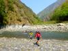
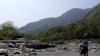
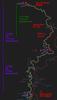
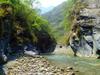
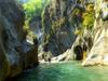
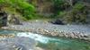
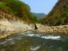
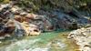
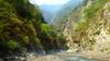
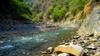
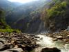
Aul misnavatan (Bunun) 丹大溪 Danda river is one of the 12 major tributaries of the Zhuoshui River 濁水溪, Taiwan’s longest river at 186 km. The headwaters of the Zhuoshui River 濁水溪 are at Hehuan mountain 合歡山 at an elevation of 3,220m. The watershed basin of the Zhuoshui River 濁水溪 has an area of 3,156.9 square kilometers. Annual average rainfall in the Zhuoshui River watershed 濁水溪流域 is 2,200 mm, which decreases moving from the mountains downstream toward the west coast. 70% to 85% of the rain falls during the rainy season from May to October, and the flow of the Zhuoshui river gradually decreases from October into the dry season in winter. The Danda river 丹大溪 quickly splits into the Danda river 丹大溪 and the Junda river 郡大溪 which each have significant tributaries all with headwaters over 3,000m.

Junda river 郡大溪 Aul misnabukun

Aul misnabukun (Bunun) 郡大溪, Junda river located in the southeast of Xinyi Township 信義鄉 of Nantou County 南投縣 is the largest and longest contributor to the Danda river 丹大溪. The headwaters of Junda river is along the southwest face of Mount Mabolasi 馬博拉斯山 at an altitude of 3,765 meters.

Junda Stream 郡大溪 Aul misnabukun P4021326
Junda river canyon
Junda Stream 郡大溪 Aul misnabukun P4021327
Junda river 郡大溪 Aul misnabukun
Junda Stream 郡大溪 Aul misnabukun P4021328
Junda river 郡大溪
Junda Stream 郡大溪 Aul misnabukun P4021330
James pushing on
Junda Stream 郡大溪 Aul misnabukun P4021331
beautiful waterfall
Junda Stream 郡大溪 Aul misnabukun P4021332
Wolfgang
Junda Stream 郡大溪 Aul misnabukun P4021337
James
Junda Stream 郡大溪 Aul misnabukun P4021342
broken canyon
Junda Stream 郡大溪 Aul misnabukun P4021343
Junda river 郡大溪
Junda Stream 郡大溪 Aul misnabukun P4021344
Junda river 郡大溪 canyon
Junda Stream 郡大溪 Aul misnabukun P4021346
Junda river 郡大溪
Junda Stream 郡大溪 Aul misnabukun 20210402_133708-980x550
Leigh coming out to help Philip across (video)
Junda Stream 郡大溪 Aul misnabukun 20210402_133800
Junda Stream 郡大溪 Aul misnabukun 20210402_134504
trees on fragile sediment
Junda Stream 郡大溪 Aul misnabukun 20210402_134519
James and Leigh

Bunun 布農 homeland

Junda Stream 郡大溪 Aul misnabukun Xinyi-Bunun-names-map
Bunun place names map

With a population of about 16,000, Nehunpu-siang (Bunun) 信義鄉 Xinyi Township, the largest township of Nantou County 南投縣 is the most populated mountain township of Taiwan. The population is roughly half Han and half indigenous, of which Bunun 布農 are 95%. The Bunun are the island's fourth-largest indigenous group.

Slot canyon camp site

Junda Stream 郡大溪 Aul misnabukun 20210402_155649
slot above our camp site
Junda Stream 郡大溪 Aul misnabukun 20210402_162501
shattered slate
Junda Stream 郡大溪 Aul misnabukun P4021348
slot above our camp site
Junda Stream 郡大溪 Aul misnabukun P4021349
first camp
Junda Stream 郡大溪 Aul misnabukun 20210402_163115
slot above our camp site
Junda Stream 郡大溪 Aul misnabukun 20210402_163200
camp site
Junda Stream 郡大溪 Aul misnabukun 20210402_163223
sediment bluffs above camp
Junda Stream 郡大溪 Aul misnabukun P4021355
looking downstream from camp
Junda Stream 郡大溪 Aul misnabukun IMG_20210402_163935_7
looking downstream from camp
Junda Stream 郡大溪 Aul misnabukun IMG_20210402_165752_1
at camp

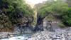
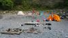
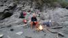
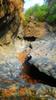
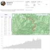
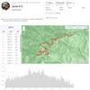
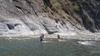
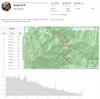
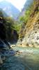
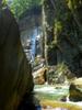
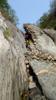
Arriving at a beautiful place to camp we decide to stop at 3:30 PM after tracing 13.85 km over 6 hours including 4 hours moving.

Junda Stream 郡大溪 Aul misnabukun Junda_4-2
14 km trace to the canyon slot camp in 4 hours

Day 2: Push toward Ivahu hot springs 伊巴厚溫泉

Slot canyon camp site

Junda Stream 郡大溪 Aul misnabukun 20210403_082231
slot above our camp site in the morning
Junda Stream 郡大溪 Aul misnabukun 20210403_082322
bluffs above camp site
Junda Stream 郡大溪 Aul misnabukun 20210403_082945
at camp
Junda Stream 郡大溪 Aul misnabukun P4031362
grasshopper?

Passing the slot

Junda Stream 郡大溪 Aul misnabukun P4031365
going through the slot
Junda Stream 郡大溪 Aul misnabukun P4031366
climbing through the slot
Junda Stream 郡大溪 Aul misnabukun P4031369
above the slot
Junda Stream 郡大溪 Aul misnabukun P4031372
above the slot
Junda Stream 郡大溪 Aul misnabukun P4031374
Junda river 郡大溪
Junda Stream 郡大溪 Aul misnabukun P4031375
Junda river 郡大溪
Junda Stream 郡大溪 Aul misnabukun P4031376
Taiwan Blue Magpie 台灣藍鵲 (tái wān lán què) Urocissa caerulea remains
Junda Stream 郡大溪 Aul misnabukun P4031380
Junda river 郡大溪
Junda Stream 郡大溪 Aul misnabukun P4031382
Junda river 郡大溪 canyon
Junda Stream 郡大溪 Aul misnabukun P4031383
Junda river 郡大溪 canyon
Junda Stream 郡大溪 Aul misnabukun P4031384
Junda river 郡大溪 canyon
Junda Stream 郡大溪 Aul misnabukun P4031385
Junda river 郡大溪 canyon

Junda Geology

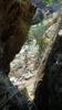
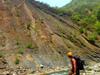
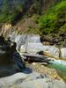
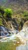
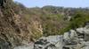
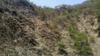
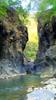
Taiwan is born of the ongoing complex collision of four different tectonic plates. This interaction results in distinct geological terranes. The Junda river canyon lies in the Western Central Range terrane. Specifically, Junda stream canyon runs right along a narrow interface between Oligocene to Miocene 漸新世一中新世 Meichi S.s. 眉溪砂岩 Miocene Suao formation on the west and Oligocene 漸新世 Chiayang formation 佳陽層 on the east side of the canyon.

Landslide

Junda Stream 郡大溪 Aul misnabukun P4031388
large landslide
Junda Stream 郡大溪 Aul misnabukun P4031389
landslide
Junda Stream 郡大溪 Aul misnabukun P4031391
Wolfgang crossing the landslide
Junda Stream 郡大溪 Aul misnabukun P4031393
deer skeleton
Junda Stream 郡大溪 Aul misnabukun P4031395
Philip and James
Junda Stream 郡大溪 Aul misnabukun P4031397
clear river level line
Junda Stream 郡大溪 Aul misnabukun P4031401
Junda river 郡大溪 canyon

Tracing with light packs and tubes to float back down to where we left our full packs on the return

Junda Stream 郡大溪 Aul misnabukun P4031404
James' art
Junda Stream 郡大溪 Aul misnabukun P4031405
who's scat?
Junda Stream 郡大溪 Aul misnabukun P4031406
atorm deposited sediment
Junda Stream 郡大溪 Aul misnabukun P4031408
Junda river 郡大溪 canyon
Junda Stream 郡大溪 Aul misnabukun P4031409
Junda river 郡大溪 canyon
Junda Stream 郡大溪 Aul misnabukun P4031412
Philip and James

Turn around point at canyon stream

Junda Stream 郡大溪 Aul misnabukun P4031413
stream cming in where we turn around
Junda Stream 郡大溪 Aul misnabukun P4031416
side stream
Junda Stream 郡大溪 Aul misnabukun IMG_20210403_143031_3
side stream

Hot springs on Junda stream

Junda Stream 郡大溪 Aul misnabukun Danda-Junda-labeled
Recent visits on Danda and Junda rivers
Junda Stream 郡大溪 Aul misnabukun Joseph-map-sketch-labled
Junda itinerary alignment with Joseph's trips

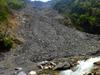
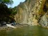
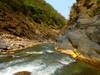
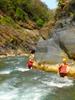
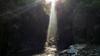
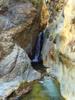
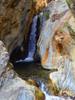
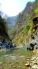
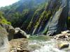
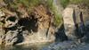
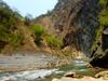
Our goal had been to reach the lower of two hot springs on Junda river. Ivahu 伊巴厚温泉 (sometimes Yibahou) remains a solid half day trace over unknown topography. We calculate that we have run out of time to reach Ivahu hot springs with enough daylight to get back to our packs and find a camp site before dark, so we regretfully turn around before reaching our goal. We leave discovery of Ivahu and Imusu hot springs 無雙溫泉 beyond to future adventures.

Formosan Sambar 臺灣水鹿

Junda Stream 郡大溪 Aul misnabukun P4031421
Formosan Sambar 臺灣水鹿 (tái wān shuǐ lù) Rusa unicolor swinhoei
Junda Stream 郡大溪 Aul misnabukun P4031443
Formosan Sambar 臺灣水鹿 (tái wān shuǐ lù) hanvang (Bunun)
Junda Stream 郡大溪 Aul misnabukun P4031452
Formosan Sambar 臺灣水鹿
Junda Stream 郡大溪 Aul misnabukun Junda-2021-Sambar-980x550
Formosan Sambar 臺灣水鹿 (video)

Deer and goats of Taiwan's lowland river canyons

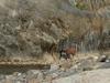
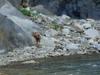
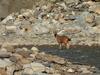
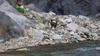
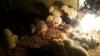
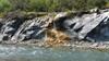
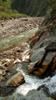
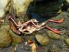
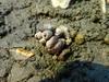
Many of the animals of lowland river canyons are active at the ends of the day (crepuscular). The prints they leave in the soft sand as they come down to water are visible sign of their presence. Sometimes we see where elders escorted their young down to the water's edge. We sometimes see the bodies of dead deer, monkeys and birds in or along the river.

Reeves's Muntjac (Barking deer)
山羌 (shān qiāng) sakut (Bunun) Muntiacus reevesi
Formosan Sambar
臺灣水鹿 (tái wān shuǐ lù) hanvang (Bunun) Rusa unicolor swinhoei
Taiwan Serow
長鬃山羊 (chǎng zōng shān yáng), 臺灣山羊 sidi (Bunun) Naemorhedus swinhoei, protected endemic bovid
size of a medium dog at 50 cm high at the shoulder, 95 cm long, tail up to 10 cm. Weighs 10 to 18 kg the largest native herbivore, can reach 1 m high, 140-180 cm long with 20 cm tail, weight of 114 kg, fur color changes with season to provide camouflage, yellowish-brown in the summer and dark brown in the winter 80–114 cm long, 25–35 kg, 10–20 cm conical horns curve backward are never shed, dark tan with yellow spots on the jaw, throat and nape
Called barking deer for their distinctive and somewhat unsettling bark. Preferred habitats are forest and shrubland. A solitary and crepuscular animal. mountain forests above 300 m, mostly nocturnal and solitary, seldom moves far from water sources. Prefers the dense cover of deciduous shrubs and grasses. Often congregate near water, and are good swimmers. Mostly 1000 to 3500 m, highly vigilant and not easy to observe. Graze in the woods alone or in small numbers at dawn and dusk. Can jump 2 m and run 20 kph. Habitats include conifer forest, mixed broad-leaved forests, and the steep slopes of bare rocks and gravel cliffs
Eats herbs, blossoms, succulent shoots, fungi, berries, grasses, nuts and tree bark Eating various grasses, foliage, fruits, leaves, water plants, herbs, buds, berries, bamboo, stems, and bark Eats leaves, vines, ferns or shrubs below shoulder height, herbs on the ground. Lick mineral deposited on cliffs or rocks to absorb needed salt

Tubing back to packs

Junda Stream 郡大溪 Aul misnabukun P4031454
walking around shallows
Junda Stream 郡大溪 Aul misnabukun P4031456
climbing around
Junda Stream 郡大溪 Aul misnabukun P4031459-978x550
Philip tubing downstream (video)
Junda Stream 郡大溪 Aul misnabukun P4031461
deflating tubes to repack full packs
Junda Stream 郡大溪 Aul misnabukun 20210403_211327
male Japanese Buerger's frog 日本樹蛙 (rì běn shù wā) Buergeria japonica
Junda Stream 郡大溪 Aul misnabukun 20210403_211655

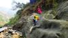
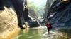
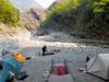
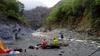
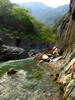
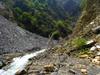
We misjudged our time and end up tracing back downstream in the dark with lights for almost an hour before finding a suitable camp site. We hike almost back down to the narrow slot site of the night before.

Junda Stream 郡大溪 Aul misnabukun Junda_4-3
17.3 km, 6 hour push toward Ivahu

Day 3: Return

Second camp

Junda Stream 郡大溪 Aul misnabukun 20210404_053454
camp site
Junda Stream 郡大溪 Aul misnabukun 20210404_053514
view from camp
Junda Stream 郡大溪 Aul misnabukun 20210404_055257
morning at camp site
Junda Stream 郡大溪 Aul misnabukun 20210404_055343
young trees holding up fractured schist
Junda Stream 郡大溪 Aul misnabukun 20210404_070025
packing up after breakfast
Junda Stream 郡大溪 Aul misnabukun 20210404_055518-070033-978x550
at camp (video)

The narrow slot

Junda Stream 郡大溪 Aul misnabukun P4041463
back through the tight slot
Junda Stream 郡大溪 Aul misnabukun P4041464
the narrow slot above our previous camp site
Junda Stream 郡大溪 Aul misnabukun P4041466
Junda Stream 郡大溪
Junda Stream 郡大溪 Aul misnabukun P4041468
revisting a waterfall
Junda Stream 郡大溪 Aul misnabukun P4041469
large stones broken
Junda Stream 郡大溪 Aul misnabukun P4041470
Junda Stream 郡大溪, Wolfgang and James
Junda Stream 郡大溪 Aul misnabukun P4041473
almost back to the Danda confluence

back to Sun Hai Bridge 孫海喬 at Heliuping 合流坪 and car

Junda Stream 郡大溪 Aul misnabukun 20210404_152738
weekend revelers at Heliuping
Junda Stream 郡大溪 Aul misnabukun IMG_20210404_152934_6
James at Heliuping
Junda Stream 郡大溪 Aul misnabukun Junda-2021-980x550
Junda 2021 (video)
Junda Stream 郡大溪 Aul misnabukun Junda_4-4
Return from second camp in 4 and a half hours over 14.3 km
Keywords: animal, bird, camping, canyon, geology, insect, landslide, mammal, map, reptile, river, video, waterfall
People: James, Leigh, Philip, Wolfgang
Locations: Dongpu, 東埔, Puli, 埔里
Dates: 2021:04:01 - 2021:04:04