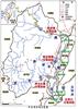

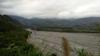
Taitung County is the southeastern corner of the island including Green Island and Orchid Island and is the third largest county in Taiwan. Taitung was the last area of the island to be colonized by Han Chinese immigrants and has remained an economic backwater. The East Rift Valley, a long and narrow valley located between the Central Mountain Range and the Coastal Mountain Range is thought to be part of the northern terminus of the Philippine Mobile Belt. The Beinan River 卑南溪 drains the southern part of this valley into the Pacific Ocean just north of Taitung city 臺東市.


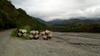


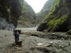
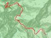
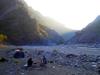
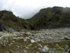
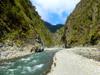
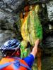
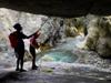
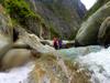
Renting a scooter at the Taitung train station 台東車站 in the early afternoon, a light rain cools the air on the drive to Qingshui bridge 清水大橋 to park and start walking. Starting late in the afternoon, I only hike in an hour to get up river far enough to be out of range of the noise and lights of civilization. Surveying the natural hot springs of Luye river, tomorrow I will trace up far enough to set a basecamp within reach of a roundtrip trace with a light pack to Taolin hot springs and hopefully allow Leigh and Raphael to catch up with me.
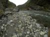
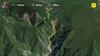
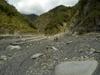
The Beinan River 卑南溪 is the main river system of Taitung County 台東縣. The river passes through seven townships over the course of its 84 kilometer flow to the Pacific Ocean. The Beinan rain catchment basin 卑南流域 covers 1600 square kilometers, draining 3 km3 per year. 75% of the annual rainfall (runoff depth) of 2,100 mm falls from May through October. Most of the sediment discharge occurs during summer typhoon events. Layers of deposited sediment cut through by a new river channel record past storms while the age and height of newly established plants in the new river channel indicate the time since the last flood. The three tributaries of the Beinan River 卑南溪 are Luye river 鹿野溪, Luliao river 鹿寮溪 and Xinwulu river 新武呂溪. The Luye river 鹿野溪 and its four hot springs all lie in Yanping Township 延平鄉 upstream from Luye township 鹿野鄉 which lies on the coast.
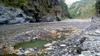
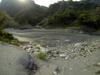
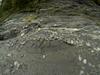
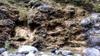
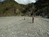
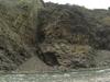
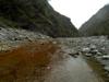
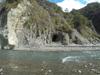
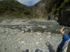
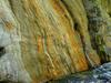
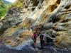
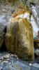
Shangli hot spring outcrop 上里溫泉, at an altitude of 282 m stretches over an area of about 500 m about 4 km upstream from Qingshui bridge 清水大橋. The outcrop emerges from cracks in the black slate of the river bed. The river is wide in the area of the hot springs so the spring appears to emerge from sand and gravel accumulated in the river bed. For this reason the location of the springs seems to change and they may even seem to disappear at times. The underlying geology is Eocene or earlier black schist formations and metamorphic sandstone. The measured water temperature has varied between 41 and 77.7 C across different surveys. The spring water was surveyed in 2008 and found to have temperature of 77.7 C. pH of 8.24, EC (electrical conductivity) of 1401 µ/cm, and TDS (total dissolved solids) of 689 mg/L. Primary mineral constituents are Na, HCO3 and SO4.
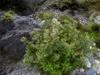
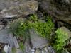
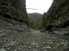
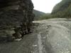
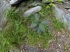
Plants in the river bed have either grown up since the last flood reached them or have established a biome protecting them from rising water. The environment in the river bed is harsh, exposed to intense water and sun. Growing in poor sandy and rocky soil, the new growth of young plants is also a favorite food of the herbivores that come down to the water's edge to drink. The small plants here may be sprouts from the surrounding established forests or other adventuring understory and pioneer species. The age of areas of plants provides indication of recent high water events and often corresponds with dramatic layers of deposited sediment. Some common representatives of this sub-zone include:
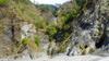
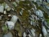
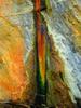
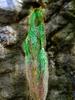
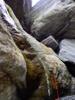
The most common origin of white seams in rock faces is fractures filled with quartz (SiO2) or calcite (CaCO3) resulting in clean straight white lines appearing to run across the surfaces of an outcrop or around a pebble. After rocks crack under pressure, the cracks may fill with fluid where crystals may precipitate forming relatively pure and clean (free of clay particles or organic matter) crystals so appearing colorless or white.
Taitung County is home to seven aboriginal groups, including Amis, Bunun, Kavalan, Paiwan, Puyuma, Rukai and Yami. Taitung County has the largest aboriginal to overall population ratio of any county or city in Taiwan, at 35.5%. These Austronesian peoples are estimated to have been living on Taiwan for approximately 6,500 years and with a total population of about 569,000 today represent 2.38% of the island's total population.
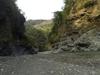
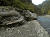
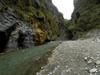
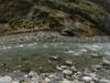
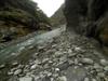
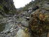
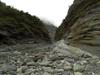
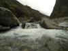
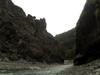
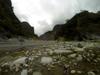
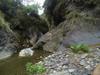
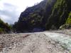
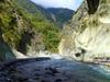
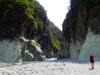
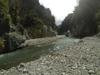
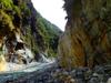
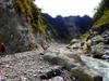
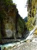
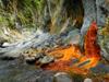
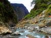
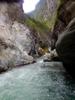
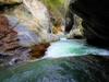
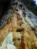
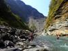
Upstream from Shangli, the river quickly narrows into a slot canyon at times less than 10 meters in width.


Luye River is also known as Beisiwan (or Pasikao) River from the Puyuma (Beinan) language word meaning bamboo. In a 1930s Japanese survey of the Luye watershed the Han characters 北絲鬮, sound for the Beinan "Pasiakao" were replaced with the Japanese katakana パシカウ (also sounding like "Pashikau").
Yanping 延平鄉 is a mountainous township in northern Taitung. The five major villages have a total population of about 3,600 of which over 90% is Bunun 布農 aborigines. Taoyuan 桃源村 is the largest of these villages, home to one third of the total population of Yanping township.
Taoyuan village was originally named Pasikau 巴喜告, meaning bamboo forest in the language of the Puyuma 卑南 language because Pasikau was once a farming ground of Puyuma aborigines and Han Chinese. When the Japanese colonial government implemented the Aborigine's Collective Movement Policy 原住民集團移住政策 to control and relocate the rebellious Taiwanese aborigines. The Japanese authority forced the Bunun people to move from their highland homeland of Laipunuk 內本鹿 in the central mountains between 1,500 and 2,000 meters, down to Pasikau (present day Taoyuan village) and the resident Puyuma and Han were moved to the villages of Luye 鹿野, Longtisn 龍田 and Chulu 初鹿.
Out of the river bed and approaching the forest the environment is less harsh than in the wet, constantly sunny and nutrient poor river bed. Here the hiker will recognize many plants underfoot familiar to the riverine/forest edge, ravines, path edge and lowland secondary growth forest. This is common understory of the Ficus-Machilus semi-evergreen foothill forest 楠榕林帶 which ranges in elevation from 100 to 500 m, enjoying an average annual temperature over 23 C where annual rainfall fluctuates between 1,000 and 4,000 mm. This forest is dominated by species of Lauraceae and Fagaceae, some common representatives of this undergrowth include:

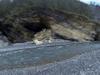

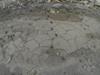
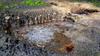
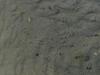
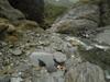
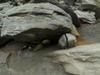
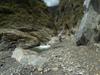
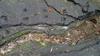
Many of the animals of the canyons are active at the ends of the day. The clearest sign of them is the prints their feet leave in the soft sand as they come down to get water. Sometimes you can see where elders escorted their young down to the water's edge. We also often see the bodies of dead deer, monkey and birds in or along the river.
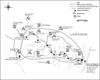
Laipunuk 內本鹿 is the traditional Bunun 布農 area in the upper catchment of Luye river 鹿野溪 including all of present day Haiduan 海端鄉 and Yanping 延平鄉 townships in Taitung County 臺東縣 as well as Taoyuan 桃源鄉 and Maolin 茂林鄉 townships in Kaohsiung County 高雄縣. A 1932 census recorded 1,597 people in 165 households in 20 villages across the Laipunuk area.
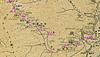
The Bunun path following Luye stream upstream into Laipunuk was called "Pasnanavan" (內本鹿) in Bunun meaning "Never-ending learning." The Japanese colonial government built this path out over five years as the Laipunuk garrison road 內本鹿警備道路 as part of their control and relocation efforts from 1924 to 1926. The 126 kilometer road started in Chulu village 初鹿村 in Taitung following Pasikao stream 北絲鬮溪 (Luye river) into the Laipunuk area, continuing westward over the central mountain range before descending into present day Kaohsiung County. The trail sometimes appears on maps as 內本鹿越嶺古道 "Laipunuk traverse trail" and 楓山古道 where 楓 invokes one of the police stations on the original garrison road. The road which connected the four hot springs of Luye stream fell into disuse after the Japanese relocated the Bunun Laipunuk villagers down into the lowlands.

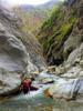
On the third day I wait until 10 AM for Leigh and Raphael to show up. Two groups of weekend hikers trace up the river in mid morning ahead of us. I walk out to learn about their adventures. Leigh and Raphael appear, we set base camp and leave together headed upstream just after 10 AM with light packs aiming for Taolin hot springs.

Taiwan is a 36,000 square kilometer subtropical island. Steep mountains over 1,000 meters in elevation cover 32% of the island; hills and terraces between 100 meters and 1,000 meters make up 31%; while alluvial plains below 100 meters, where most human activity is concentrated, cover the remaining 37%. The northeast monsoon prevails from October through March. Typhoons and thunderstorms bring in abundant rainfall from May through September. The mountains are dominated by fractured, and deeply weathered metamorphic and sedimentary rock. Intense rainfall and flow of flood water causes severe erosion which is compounded by earthquakes which undermine the stability of the slopes. The rivers of the island's 16 major watersheds are short and steep, becoming torrential during heavy storms. About 78% of annual precipitation falls from May through October, with most water delivered by storms and typhoons. Average annual rainfall is 2,515 millimeters or 90.5 billion cubic meters. Average annual runoff is 66.8 billion cubic meters, of which only 23% or about 15.4 billion cubic meters, are available for the use during the dry period from October through April. Annual pumped groundwater is estimated at 7.1 billion cubic meters.

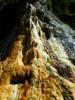
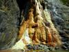
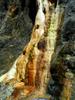

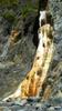


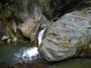
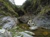
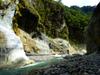
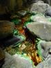
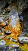
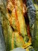
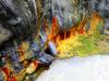
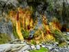
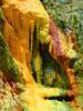
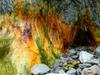
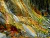
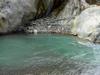
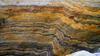
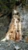
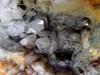
The main Taolin hot spring outcrop 桃林溫泉 is at the confluence of Luye stream 鹿野北溪 and Malalaou stream 瑪拉拉歐溪 (sometimes called Luye South stream 鹿野南溪) at an altitude of 555m. There are also records of hot spring outcrops 瑪拉拉歐溪溫泉 about 300 m further upstream on Malalaou stream 瑪拉拉歐溪. The Taolin outcrop emerges from cracks in the gray-white marble of the Luye River canyon bed as well as sand and gravel in the river bed. At outcrops in the north branch of Luye river, the hot water sprays out from cracks in the black slate of the river canyon leaving behind copious amounts of calcium carbonate deposited in beautiful layers around the outcrops. Minor outcrops can be found along the north branch of the stream for about 300 meters upstream of the main outcrop at the confluence. The underlying geology is late Paleozoic-Mesozoic schist and marble. Water temperature was measured at 93C with a pH of 9.21, EC (electrical conductivity) of 2260 µS/cm, and TDS (total dissolved solids) of 1840 mg/L. Primary mineral constituents were Na, K, Mg, Ca and Al.
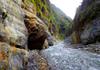


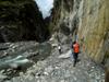
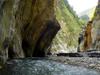

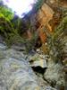
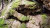
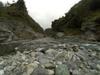
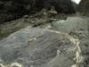
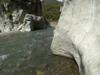
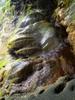
Highly polished white marble canyon walls bear testimony to the formidable volume of water that regularly passes through the canyon.


There are approximately 4300 species of vascular plants in Taiwan, including ferns, gymnosperms, and flowering plants which express species as trees, shrubs, vines and herbs. Where the forest is able to establish further up the bank away from the river, the trees are a subset of the Ficus-Machilus semi-evergreen foothill forest 楠榕林帶 which ranges in elevation from 100 to 500 m and enjoying an average annual temp over 23 C where annual rainfall fluctuates between 1,000 and 4,000 mm. This forest is dominated by species of Lauraceae and Fagaceae, some common representatives include:


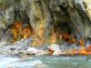
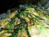

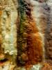

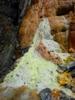
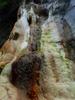
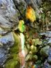
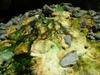
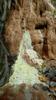
As hot water flows from the outcrop it may fill small pools where it will overflow forming a slowly accumulating wall of calcium carbonate precipitate at the edge, undisturbed this will grow steps of overflow deposits called travertine terraces 石灰華階地. These terraces host algae populations which provide vivid coloration which varies with the varying temperature of successive terraces. These are colloquilly called 蛋糕狀石灰華池 in Chinese "Travertine cake pools."


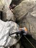
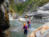
At the main Taolin outcrop we catch up with the group of young people who had passed us at our basecamp in the morning. They catch up with us negotiating the giant boulder of the "Dragon's Gate 龍門." We help their group get past the boulder but decide that we are not up for the dodgy climb. The gate proves an impassable block for many river tracers aiming to reach the upper Taolin outcrop. So we also put off a visit to our ultimate goal of the Upper Taolin hot springs to a later adventure. Much later, settled back at our basecamp, in the last minutes of daylight of the day, the group of young people go floating by on tubes destined for their basecamp near Shangli.


Hoodoos typically form in areas where a thick layer of a relatively soft rock, such as mudstone, poorly cemented sandstone, or tuff, is covered by a thin layer of hard rock, such as well-cemented sandstone, limestone, or basalt. Hoodoos form where a small cap of harder material remains, and protects a cone of the underlying softer layer from erosion. The heavy cap pressing downward gives the pedestal of the hoodoo its strength to resist erosion.
The Taiwan Cycad Reserve 臺東蘇鐵自然保護區 was established in 1980 on the steep gravel slopes of the lower Luye river 鹿野溪. The reserve covers 290 ha across an altitude range of 300 to 900 m along 7 km of the north bank of the Luye river. Taitung cycad 台東蘇鐵 (tái dōng sū tiě) Cycas taitungensis, unchanged from over 140 million years is one of the oldest “living fossils” in the world. The endemic gymnosperm thrives in the loamy sandy soil on steep slopes composed of crumbly Eocene slate and phylite and late Palaeozoic through Mesozoic black schist. The dioecious plant grows 1 to 5 m high. It has flat round seeds rich in starch, which serves as food for smaller mammals. there are 1744 cycads recorded in the reserve.
The downstream trace is quick leaving us time to arrange a stress-free trip back to Taipei after a one hour scooter ride to the Taidong train station in light rain. On the way back I take Leigh and Raphael up the stunning Langsu stream 浪速溪 and canyon again.